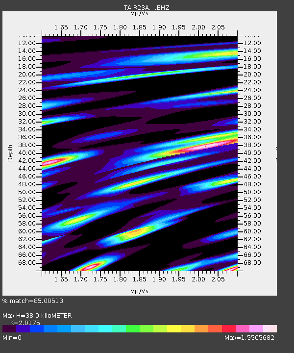
R23A Moffat, CO, USA - Earthquake Result Viewer
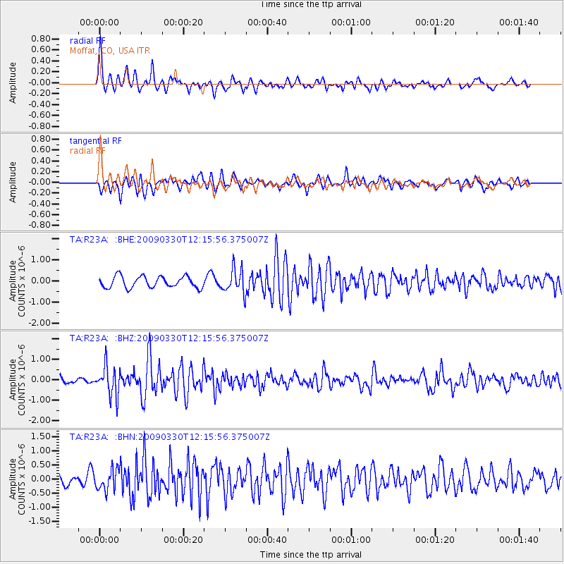
Earthquake location: Andreanof Islands, Aleutian Is.
Earthquake latitude/longitude: 51.5/-178.3
Earthquake time(UTC): 2009/03/30 (089) 12:07:28 GMT
Earthquake Depth: 31 km
Earthquake Magnitude: 6.0 MB, 5.5 MS, 5.7 MW, 5.7 MW
Earthquake Catalog/Contributor: WHDF/NEIC
Network: TA USArray Transportable Network (new EarthScope stations)
Station: R23A Moffat, CO, USA
Lat/Lon: 38.19 N/105.83 W
Elevation: 2547 m
Distance: 51.0 deg
Az: 75.175 deg
Baz: 309.979 deg
Ray Param: 0.06763679
Estimated Moho Depth: 38.0 km
Estimated Crust Vp/Vs: 2.02
Assumed Crust Vp: 6.159 km/s
Estimated Crust Vs: 3.053 km/s
Estimated Crust Poisson's Ratio: 0.34
Radial Match: 85.00513 %
Radial Bump: 400
Transverse Match: 67.44603 %
Transverse Bump: 400
SOD ConfigId: 2658
Insert Time: 2010-03-06 19:54:27.297 +0000
GWidth: 2.5
Max Bumps: 400
Tol: 0.001

Signal To Noise

ChannelStoNSTALTA
TA:R23A: :BHZ:20090330T12:15:56.375007Z3.95162277.4203444E-71.8777968E-7
TA:R23A: :BHN:20090330T12:15:56.375007Z2.02570253.7290465E-71.840866E-7
TA:R23A: :BHE:20090330T12:15:56.375007Z2.17175965.8103655E-72.6754182E-7
Arrivals
Ps6.6 SECOND
PpPs18 SECOND
PsPs/PpSs24 SECOND