You are here: Home > Network List > RV - Regional Alberta Seismic Observatory for Earthquake Studies Network Stations List
> Station REDDA Red Deer Airport, AB > Earthquake Result Viewer
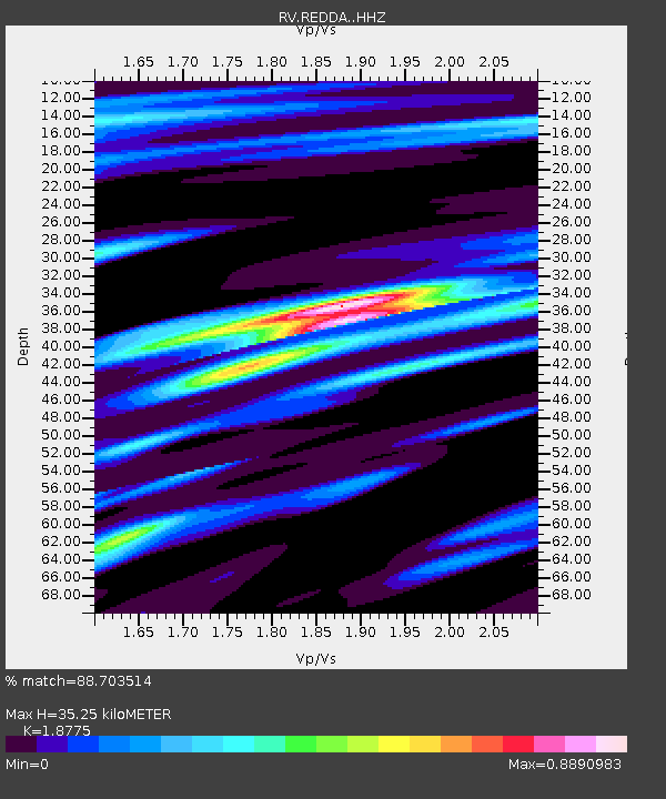
REDDA Red Deer Airport, AB - Earthquake Result Viewer
| Earthquake location: |
Near Coast Of Chiapas, Mexico |
| Earthquake latitude/longitude: |
14.8/-92.3 |
| Earthquake time(UTC): |
2019/02/01 (032) 16:14:13 GMT |
| Earthquake Depth: |
68 km |
| Earthquake Magnitude: |
6.6 Mww |
| Earthquake Catalog/Contributor: |
NEIC PDE/us |
|
| Network: |
RV Regional Alberta Seismic Observatory for Earthquake Studies Network |
| Station: |
REDDA Red Deer Airport, AB |
| Lat/Lon: |
52.18 N/113.90 W |
| Elevation: |
892 m |
|
| Distance: |
41.1 deg |
| Az: |
339.832 deg |
| Baz: |
147.202 deg |
| Ray Param: |
0.0737797 |
| Estimated Moho Depth: |
35.25 km |
| Estimated Crust Vp/Vs: |
1.88 |
| Assumed Crust Vp: |
6.483 km/s |
| Estimated Crust Vs: |
3.453 km/s |
| Estimated Crust Poisson's Ratio: |
0.30 |
|
| Radial Match: |
88.703514 % |
| Radial Bump: |
257 |
| Transverse Match: |
70.0298 % |
| Transverse Bump: |
312 |
| SOD ConfigId: |
13570011 |
| Insert Time: |
2019-05-02 11:16:10.090 +0000 |
| GWidth: |
2.5 |
| Max Bumps: |
400 |
| Tol: |
0.001 |
|

Signal To Noise
| Channel | StoN | STA | LTA |
| RV:REDDA: :HHZ:20190201T16:21:20.010013Z | 18.124226 | 5.1746015E-6 | 2.8550744E-7 |
| RV:REDDA: :HHN:20190201T16:21:20.010013Z | 2.7295325 | 1.5315557E-6 | 5.611055E-7 |
| RV:REDDA: :HHE:20190201T16:21:20.010013Z | 8.024981 | 2.288094E-6 | 2.8512144E-7 |
| Arrivals |
| Ps | 5.1 SECOND |
| PpPs | 15 SECOND |
| PsPs/PpSs | 20 SECOND |


