You are here: Home > Network List > TA - USArray Transportable Network (new EarthScope stations) Stations List
> Station B18K Kokolik River, AK, USA > Earthquake Result Viewer
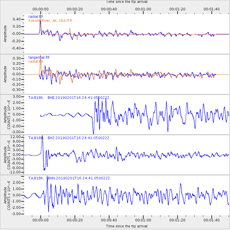
B18K Kokolik River, AK, USA - Earthquake Result Viewer
| Earthquake location: |
Near Coast Of Chiapas, Mexico |
| Earthquake latitude/longitude: |
14.8/-92.3 |
| Earthquake time(UTC): |
2019/02/01 (032) 16:14:13 GMT |
| Earthquake Depth: |
68 km |
| Earthquake Magnitude: |
6.6 Mww |
| Earthquake Catalog/Contributor: |
NEIC PDE/us |
|
| Network: |
TA USArray Transportable Network (new EarthScope stations) |
| Station: |
B18K Kokolik River, AK, USA |
| Lat/Lon: |
69.36 N/161.80 W |
| Elevation: |
222 m |
|
| Distance: |
69.1 deg |
| Az: |
339.178 deg |
| Baz: |
104.062 deg |
| Ray Param: |
0.055720814 |
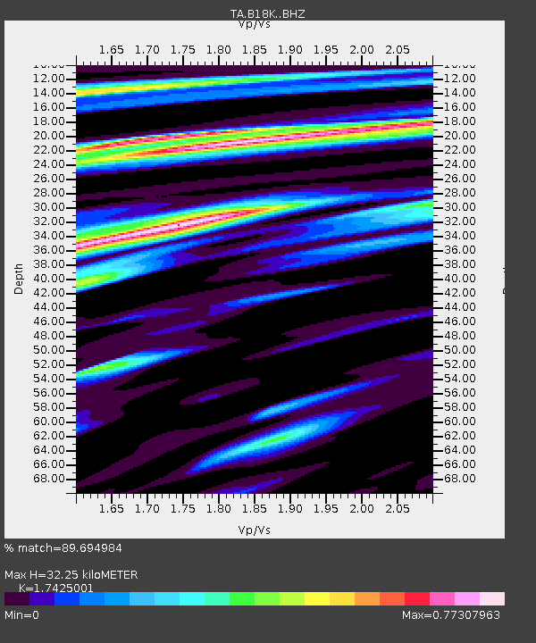
| Estimated Moho Depth: |
32.25 km |
| Estimated Crust Vp/Vs: |
1.74 |
| Assumed Crust Vp: |
5.906 km/s |
| Estimated Crust Vs: |
3.39 km/s |
| Estimated Crust Poisson's Ratio: |
0.25 |
|
| Radial Match: |
89.694984 % |
| Radial Bump: |
400 |
| Transverse Match: |
86.27426 % |
| Transverse Bump: |
400 |
| SOD ConfigId: |
13570011 |
| Insert Time: |
2019-05-02 11:16:21.001 +0000 |
| GWidth: |
2.5 |
| Max Bumps: |
400 |
| Tol: |
0.001 |
|
Signal To Noise
| Channel | StoN | STA | LTA |
| TA:B18K: :BHZ:20190201T16:24:41.050022Z | 35.078453 | 6.391053E-6 | 1.8219312E-7 |
| TA:B18K: :BHN:20190201T16:24:41.050022Z | 4.991561 | 1.103239E-6 | 2.2102085E-7 |
| TA:B18K: :BHE:20190201T16:24:41.050022Z | 9.427766 | 1.6320918E-6 | 1.7311544E-7 |
| Arrivals |
| Ps | 4.2 SECOND |
| PpPs | 14 SECOND |
| PsPs/PpSs | 19 SECOND |


