You are here: Home > Network List > GS - US Geological Survey Networks Stations List
> Station OK045 Pawnee, OK, Station 45 > Earthquake Result Viewer
OK045 Pawnee, OK, Station 45 - Earthquake Result Viewer
| Earthquake location: |
Northern Colombia |
| Earthquake latitude/longitude: |
7.3/-76.1 |
| Earthquake time(UTC): |
2016/09/14 (258) 01:58:30 GMT |
| Earthquake Depth: |
10 km |
| Earthquake Magnitude: |
5.9 MWP |
| Earthquake Catalog/Contributor: |
NEIC PDE/NEIC COMCAT |
|
| Network: |
GS US Geological Survey Networks |
| Station: |
OK045 Pawnee, OK, Station 45 |
| Lat/Lon: |
36.45 N/96.92 W |
| Elevation: |
284 m |
|
| Distance: |
34.7 deg |
| Az: |
329.736 deg |
| Baz: |
141.683 deg |
| Ray Param: |
0.07762448 |
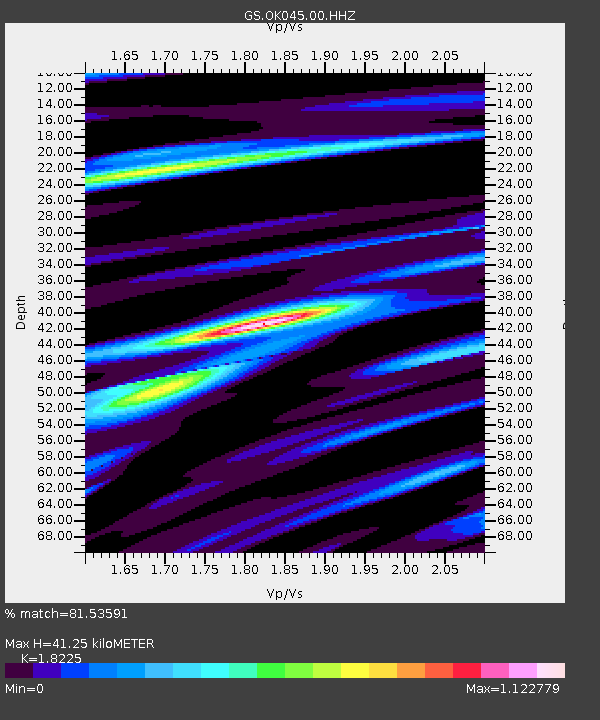
| Estimated Moho Depth: |
41.25 km |
| Estimated Crust Vp/Vs: |
1.82 |
| Assumed Crust Vp: |
6.483 km/s |
| Estimated Crust Vs: |
3.557 km/s |
| Estimated Crust Poisson's Ratio: |
0.28 |
|
| Radial Match: |
81.53591 % |
| Radial Bump: |
370 |
| Transverse Match: |
65.00911 % |
| Transverse Bump: |
385 |
| SOD ConfigId: |
1634031 |
| Insert Time: |
2016-09-28 01:59:45.712 +0000 |
| GWidth: |
2.5 |
| Max Bumps: |
400 |
| Tol: |
0.001 |
|

Signal To Noise
| Channel | StoN | STA | LTA |
| GS:OK045:00:HHZ:20160914T02:04:49.179011Z | 6.581807 | 9.585616E-7 | 1.4563805E-7 |
| GS:OK045:00:HH1:20160914T02:04:49.179011Z | 3.2529185 | 5.51991E-7 | 1.6969099E-7 |
| GS:OK045:00:HH2:20160914T02:04:49.179011Z | 2.7842627 | 5.1513643E-7 | 1.8501719E-7 |
| Arrivals |
| Ps | 5.6 SECOND |
| PpPs | 17 SECOND |
| PsPs/PpSs | 22 SECOND |


