You are here: Home > Network List > TA - USArray Transportable Network (new EarthScope stations) Stations List
> Station C18K Utukok River, AK, USA > Earthquake Result Viewer
C18K Utukok River, AK, USA - Earthquake Result Viewer
| Earthquake location: |
Near Coast Of Chiapas, Mexico |
| Earthquake latitude/longitude: |
14.8/-92.3 |
| Earthquake time(UTC): |
2019/02/01 (032) 16:14:13 GMT |
| Earthquake Depth: |
68 km |
| Earthquake Magnitude: |
6.6 Mww |
| Earthquake Catalog/Contributor: |
NEIC PDE/us |
|
| Network: |
TA USArray Transportable Network (new EarthScope stations) |
| Station: |
C18K Utukok River, AK, USA |
| Lat/Lon: |
68.65 N/161.19 W |
| Elevation: |
845 m |
|
| Distance: |
68.7 deg |
| Az: |
338.488 deg |
| Baz: |
104.38 deg |
| Ray Param: |
0.055975486 |
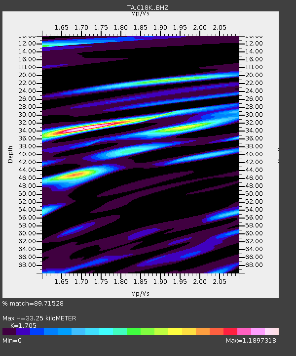
| Estimated Moho Depth: |
33.25 km |
| Estimated Crust Vp/Vs: |
1.71 |
| Assumed Crust Vp: |
5.906 km/s |
| Estimated Crust Vs: |
3.464 km/s |
| Estimated Crust Poisson's Ratio: |
0.24 |
|
| Radial Match: |
89.71528 % |
| Radial Bump: |
400 |
| Transverse Match: |
83.770874 % |
| Transverse Bump: |
400 |
| SOD ConfigId: |
13570011 |
| Insert Time: |
2019-05-02 11:16:25.603 +0000 |
| GWidth: |
2.5 |
| Max Bumps: |
400 |
| Tol: |
0.001 |
|

Signal To Noise
| Channel | StoN | STA | LTA |
| TA:C18K: :BHZ:20190201T16:24:38.649998Z | 33.775513 | 3.5389642E-6 | 1.04778984E-7 |
| TA:C18K: :BHN:20190201T16:24:38.649998Z | 5.1425743 | 9.844559E-7 | 1.9143252E-7 |
| TA:C18K: :BHE:20190201T16:24:38.649998Z | 15.4878845 | 1.230596E-6 | 7.94554E-8 |
| Arrivals |
| Ps | 4.1 SECOND |
| PpPs | 15 SECOND |
| PsPs/PpSs | 19 SECOND |


