You are here: Home > Network List > TA - USArray Transportable Network (new EarthScope stations) Stations List
> Station D24K Happy Valley, AK, USA > Earthquake Result Viewer
D24K Happy Valley, AK, USA - Earthquake Result Viewer
| Earthquake location: |
Near Coast Of Chiapas, Mexico |
| Earthquake latitude/longitude: |
14.8/-92.3 |
| Earthquake time(UTC): |
2019/02/01 (032) 16:14:13 GMT |
| Earthquake Depth: |
68 km |
| Earthquake Magnitude: |
6.6 Mww |
| Earthquake Catalog/Contributor: |
NEIC PDE/us |
|
| Network: |
TA USArray Transportable Network (new EarthScope stations) |
| Station: |
D24K Happy Valley, AK, USA |
| Lat/Lon: |
69.15 N/148.82 W |
| Elevation: |
292 m |
|
| Distance: |
64.7 deg |
| Az: |
340.714 deg |
| Baz: |
116.799 deg |
| Ray Param: |
0.058596198 |
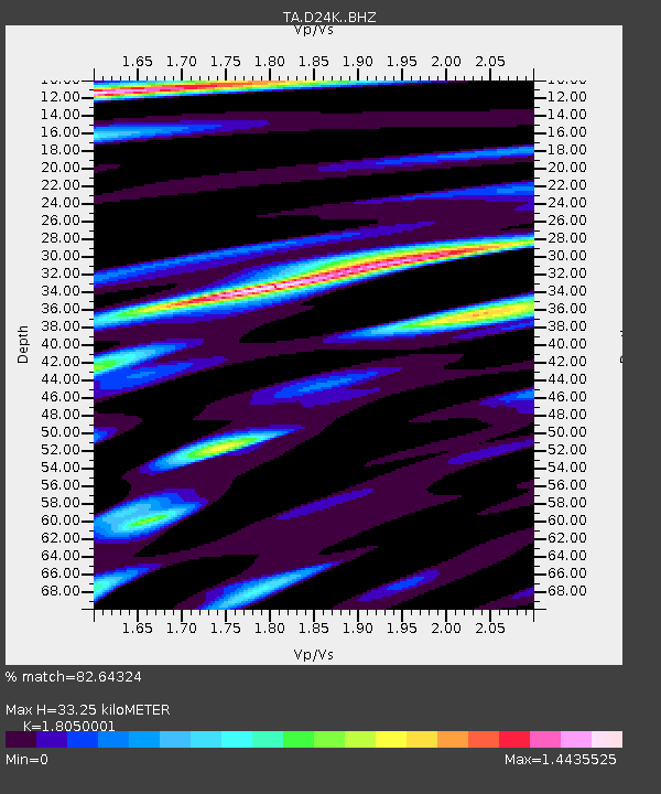
| Estimated Moho Depth: |
33.25 km |
| Estimated Crust Vp/Vs: |
1.81 |
| Assumed Crust Vp: |
6.316 km/s |
| Estimated Crust Vs: |
3.499 km/s |
| Estimated Crust Poisson's Ratio: |
0.28 |
|
| Radial Match: |
82.64324 % |
| Radial Bump: |
400 |
| Transverse Match: |
82.6451 % |
| Transverse Bump: |
400 |
| SOD ConfigId: |
13570011 |
| Insert Time: |
2019-05-02 11:16:32.713 +0000 |
| GWidth: |
2.5 |
| Max Bumps: |
400 |
| Tol: |
0.001 |
|
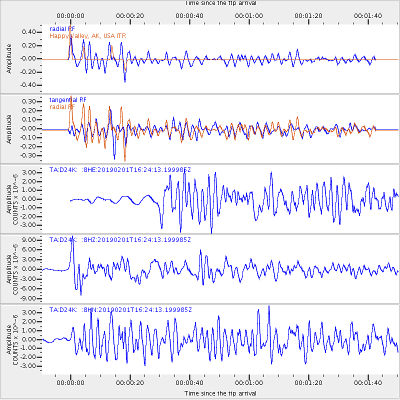
Signal To Noise
| Channel | StoN | STA | LTA |
| TA:D24K: :BHZ:20190201T16:24:13.199985Z | 18.895191 | 4.899547E-6 | 2.5930126E-7 |
| TA:D24K: :BHN:20190201T16:24:13.199985Z | 4.6224923 | 9.374077E-7 | 2.0279272E-7 |
| TA:D24K: :BHE:20190201T16:24:13.199985Z | 6.570478 | 1.6510146E-6 | 2.512777E-7 |
| Arrivals |
| Ps | 4.4 SECOND |
| PpPs | 14 SECOND |
| PsPs/PpSs | 19 SECOND |


