You are here: Home > Network List > TA - USArray Transportable Network (new EarthScope stations) Stations List
> Station E20K Nigu River, AK, USA > Earthquake Result Viewer
E20K Nigu River, AK, USA - Earthquake Result Viewer

| Earthquake location: |
Near Coast Of Chiapas, Mexico |
| Earthquake latitude/longitude: |
14.8/-92.3 |
| Earthquake time(UTC): |
2019/02/01 (032) 16:14:13 GMT |
| Earthquake Depth: |
68 km |
| Earthquake Magnitude: |
6.6 Mww |
| Earthquake Catalog/Contributor: |
NEIC PDE/us |
|
| Network: |
TA USArray Transportable Network (new EarthScope stations) |
| Station: |
E20K Nigu River, AK, USA |
| Lat/Lon: |
68.26 N/156.19 W |
| Elevation: |
866 m |
|
| Distance: |
66.8 deg |
| Az: |
338.657 deg |
| Baz: |
109.096 deg |
| Ray Param: |
0.057200946 |
| Estimated Moho Depth: |
31.0 km |
| Estimated Crust Vp/Vs: |
1.66 |
| Assumed Crust Vp: |
6.221 km/s |
| Estimated Crust Vs: |
3.748 km/s |
| Estimated Crust Poisson's Ratio: |
0.22 |
|
| Radial Match: |
90.61336 % |
| Radial Bump: |
400 |
| Transverse Match: |
82.22723 % |
| Transverse Bump: |
400 |
| SOD ConfigId: |
13570011 |
| Insert Time: |
2019-05-02 11:16:37.209 +0000 |
| GWidth: |
2.5 |
| Max Bumps: |
400 |
| Tol: |
0.001 |
|
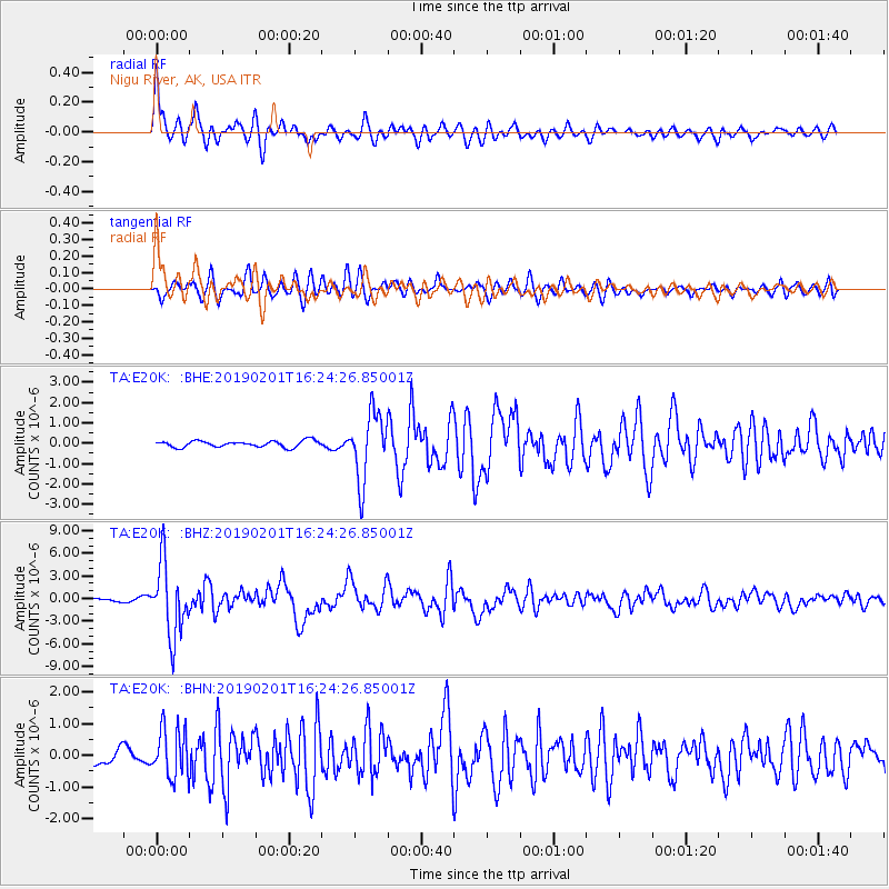
Signal To Noise
| Channel | StoN | STA | LTA |
| TA:E20K: :BHZ:20190201T16:24:26.85001Z | 31.46528 | 4.7841186E-6 | 1.5204436E-7 |
| TA:E20K: :BHN:20190201T16:24:26.85001Z | 4.2940583 | 7.70966E-7 | 1.7954251E-7 |
| TA:E20K: :BHE:20190201T16:24:26.85001Z | 10.639923 | 1.6549498E-6 | 1.5554151E-7 |
| Arrivals |
| Ps | 3.4 SECOND |
| PpPs | 13 SECOND |
| PsPs/PpSs | 16 SECOND |


