You are here: Home > Network List > TA - USArray Transportable Network (new EarthScope stations) Stations List
> Station R23A Moffat, CO, USA > Earthquake Result Viewer
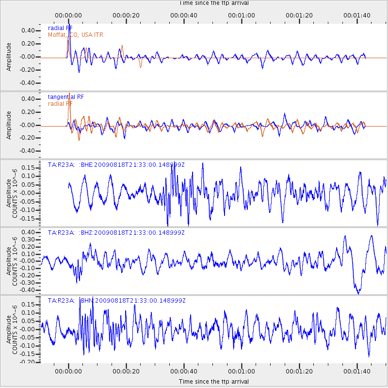
R23A Moffat, CO, USA - Earthquake Result Viewer
*The percent match for this event was below the threshold and hence no stack was calculated.
| Earthquake location: |
South Of Fiji Islands |
| Earthquake latitude/longitude: |
-26.1/-178.4 |
| Earthquake time(UTC): |
2009/08/18 (230) 21:20:47 GMT |
| Earthquake Depth: |
270 km |
| Earthquake Magnitude: |
5.5 MB, 6.3 MW, 6.3 MW |
| Earthquake Catalog/Contributor: |
WHDF/NEIC |
|
| Network: |
TA USArray Transportable Network (new EarthScope stations) |
| Station: |
R23A Moffat, CO, USA |
| Lat/Lon: |
38.19 N/105.83 W |
| Elevation: |
2547 m |
|
| Distance: |
93.3 deg |
| Az: |
48.849 deg |
| Baz: |
239.263 deg |
| Ray Param: |
$rayparam |
*The percent match for this event was below the threshold and hence was not used in the summary stack. |
|
| Radial Match: |
71.001 % |
| Radial Bump: |
400 |
| Transverse Match: |
59.947643 % |
| Transverse Bump: |
400 |
| SOD ConfigId: |
2622 |
| Insert Time: |
2010-03-06 19:54:41.842 +0000 |
| GWidth: |
2.5 |
| Max Bumps: |
400 |
| Tol: |
0.001 |
|
Signal To Noise
| Channel | StoN | STA | LTA |
| TA:R23A: :BHZ:20090818T21:33:00.148999Z | 2.4967697 | 1.232029E-7 | 4.9344916E-8 |
| TA:R23A: :BHN:20090818T21:33:00.148999Z | 1.0886441 | 5.229832E-8 | 4.8039865E-8 |
| TA:R23A: :BHE:20090818T21:33:00.148999Z | 1.1890293 | 6.217904E-8 | 5.229395E-8 |
| Arrivals |
| Ps | |
| PpPs | |
| PsPs/PpSs | |


