You are here: Home > Network List > TA - USArray Transportable Network (new EarthScope stations) Stations List
> Station J17K VABM Dome, AK, USA > Earthquake Result Viewer
J17K VABM Dome, AK, USA - Earthquake Result Viewer
| Earthquake location: |
Near Coast Of Chiapas, Mexico |
| Earthquake latitude/longitude: |
14.8/-92.3 |
| Earthquake time(UTC): |
2019/02/01 (032) 16:14:13 GMT |
| Earthquake Depth: |
68 km |
| Earthquake Magnitude: |
6.6 Mww |
| Earthquake Catalog/Contributor: |
NEIC PDE/us |
|
| Network: |
TA USArray Transportable Network (new EarthScope stations) |
| Station: |
J17K VABM Dome, AK, USA |
| Lat/Lon: |
63.40 N/159.08 W |
| Elevation: |
323 m |
|
| Distance: |
66.6 deg |
| Az: |
333.194 deg |
| Baz: |
104.297 deg |
| Ray Param: |
0.05737517 |
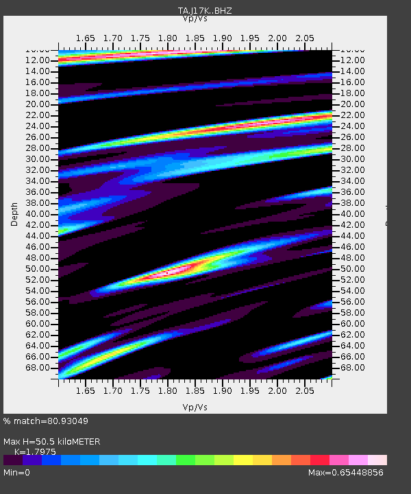
| Estimated Moho Depth: |
50.5 km |
| Estimated Crust Vp/Vs: |
1.80 |
| Assumed Crust Vp: |
6.276 km/s |
| Estimated Crust Vs: |
3.491 km/s |
| Estimated Crust Poisson's Ratio: |
0.28 |
|
| Radial Match: |
80.93049 % |
| Radial Bump: |
400 |
| Transverse Match: |
74.80374 % |
| Transverse Bump: |
400 |
| SOD ConfigId: |
13570011 |
| Insert Time: |
2019-05-02 11:17:21.022 +0000 |
| GWidth: |
2.5 |
| Max Bumps: |
400 |
| Tol: |
0.001 |
|

Signal To Noise
| Channel | StoN | STA | LTA |
| TA:J17K: :BHZ:20190201T16:24:25.175022Z | 11.938164 | 2.6780608E-6 | 2.243277E-7 |
| TA:J17K: :BHN:20190201T16:24:25.175022Z | 2.164394 | 3.1398753E-7 | 1.4506949E-7 |
| TA:J17K: :BHE:20190201T16:24:25.175022Z | 5.2691736 | 1.2841981E-6 | 2.437191E-7 |
| Arrivals |
| Ps | 6.7 SECOND |
| PpPs | 22 SECOND |
| PsPs/PpSs | 28 SECOND |


