You are here: Home > Network List > TA - USArray Transportable Network (new EarthScope stations) Stations List
> Station J29N Klondike Camp, Yukon, CA > Earthquake Result Viewer
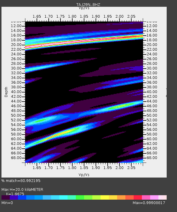
J29N Klondike Camp, Yukon, CA - Earthquake Result Viewer
| Earthquake location: |
Near Coast Of Chiapas, Mexico |
| Earthquake latitude/longitude: |
14.8/-92.3 |
| Earthquake time(UTC): |
2019/02/01 (032) 16:14:13 GMT |
| Earthquake Depth: |
68 km |
| Earthquake Magnitude: |
6.6 Mww |
| Earthquake Catalog/Contributor: |
NEIC PDE/us |
|
| Network: |
TA USArray Transportable Network (new EarthScope stations) |
| Station: |
J29N Klondike Camp, Yukon, CA |
| Lat/Lon: |
64.45 N/138.22 W |
| Elevation: |
982 m |
|
| Distance: |
58.7 deg |
| Az: |
338.612 deg |
| Baz: |
125.552 deg |
| Ray Param: |
0.06251817 |
| Estimated Moho Depth: |
20.0 km |
| Estimated Crust Vp/Vs: |
1.67 |
| Assumed Crust Vp: |
6.566 km/s |
| Estimated Crust Vs: |
3.938 km/s |
| Estimated Crust Poisson's Ratio: |
0.22 |
|
| Radial Match: |
80.992195 % |
| Radial Bump: |
400 |
| Transverse Match: |
68.551384 % |
| Transverse Bump: |
400 |
| SOD ConfigId: |
13570011 |
| Insert Time: |
2019-05-02 11:17:26.084 +0000 |
| GWidth: |
2.5 |
| Max Bumps: |
400 |
| Tol: |
0.001 |
|

Signal To Noise
| Channel | StoN | STA | LTA |
| TA:J29N: :BHZ:20190201T16:23:32.774998Z | 9.959614 | 2.705258E-6 | 2.7162278E-7 |
| TA:J29N: :BHN:20190201T16:23:32.774998Z | 4.74253 | 9.650546E-7 | 2.0348942E-7 |
| TA:J29N: :BHE:20190201T16:23:32.774998Z | 3.772294 | 1.0741434E-6 | 2.847454E-7 |
| Arrivals |
| Ps | 2.1 SECOND |
| PpPs | 7.7 SECOND |
| PsPs/PpSs | 9.8 SECOND |


