You are here: Home > Network List > TA - USArray Transportable Network (new EarthScope stations) Stations List
> Station M29M Somme Creek, YT, CAN > Earthquake Result Viewer
M29M Somme Creek, YT, CAN - Earthquake Result Viewer
| Earthquake location: |
Near Coast Of Chiapas, Mexico |
| Earthquake latitude/longitude: |
14.8/-92.3 |
| Earthquake time(UTC): |
2019/02/01 (032) 16:14:13 GMT |
| Earthquake Depth: |
68 km |
| Earthquake Magnitude: |
6.6 Mww |
| Earthquake Catalog/Contributor: |
NEIC PDE/us |
|
| Network: |
TA USArray Transportable Network (new EarthScope stations) |
| Station: |
M29M Somme Creek, YT, CAN |
| Lat/Lon: |
62.44 N/138.46 W |
| Elevation: |
1297 m |
|
| Distance: |
57.6 deg |
| Az: |
336.59 deg |
| Baz: |
124.264 deg |
| Ray Param: |
0.06320911 |
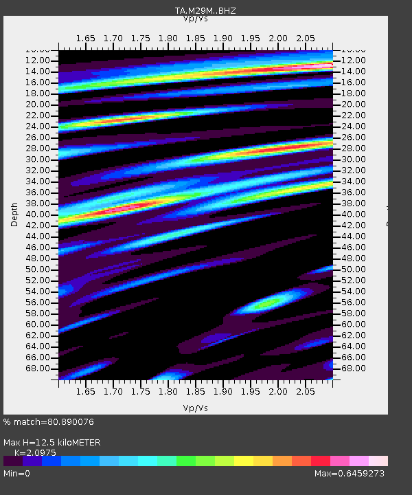
| Estimated Moho Depth: |
12.5 km |
| Estimated Crust Vp/Vs: |
2.10 |
| Assumed Crust Vp: |
6.566 km/s |
| Estimated Crust Vs: |
3.13 km/s |
| Estimated Crust Poisson's Ratio: |
0.35 |
|
| Radial Match: |
80.890076 % |
| Radial Bump: |
400 |
| Transverse Match: |
73.99278 % |
| Transverse Bump: |
400 |
| SOD ConfigId: |
13570011 |
| Insert Time: |
2019-05-02 11:17:50.982 +0000 |
| GWidth: |
2.5 |
| Max Bumps: |
400 |
| Tol: |
0.001 |
|

Signal To Noise
| Channel | StoN | STA | LTA |
| TA:M29M: :BHZ:20190201T16:23:25.35001Z | 18.34751 | 4.712846E-6 | 2.568657E-7 |
| TA:M29M: :BHN:20190201T16:23:25.35001Z | 9.145287 | 1.3239135E-6 | 1.4476457E-7 |
| TA:M29M: :BHE:20190201T16:23:25.35001Z | 8.05035 | 1.8562597E-6 | 2.3058124E-7 |
| Arrivals |
| Ps | 2.2 SECOND |
| PpPs | 5.6 SECOND |
| PsPs/PpSs | 7.8 SECOND |


