You are here: Home > Network List > TA - USArray Transportable Network (new EarthScope stations) Stations List
> Station R23A Moffat, CO, USA > Earthquake Result Viewer
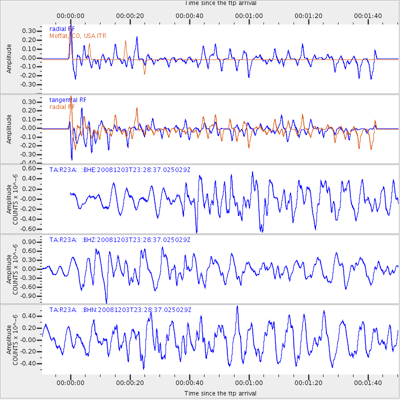
R23A Moffat, CO, USA - Earthquake Result Viewer
*The percent match for this event was below the threshold and hence no stack was calculated.
| Earthquake location: |
Near East Coast Of Honshu, Japan |
| Earthquake latitude/longitude: |
38.6/142.9 |
| Earthquake time(UTC): |
2008/12/03 (338) 23:16:54 GMT |
| Earthquake Depth: |
14 km |
| Earthquake Magnitude: |
5.6 MB, 5.5 MS, 5.8 MW, 5.8 MW |
| Earthquake Catalog/Contributor: |
WHDF/NEIC |
|
| Network: |
TA USArray Transportable Network (new EarthScope stations) |
| Station: |
R23A Moffat, CO, USA |
| Lat/Lon: |
38.19 N/105.83 W |
| Elevation: |
2547 m |
|
| Distance: |
80.9 deg |
| Az: |
48.033 deg |
| Baz: |
312.313 deg |
| Ray Param: |
$rayparam |
*The percent match for this event was below the threshold and hence was not used in the summary stack. |
|
| Radial Match: |
68.4335 % |
| Radial Bump: |
400 |
| Transverse Match: |
77.79059 % |
| Transverse Bump: |
400 |
| SOD ConfigId: |
2658 |
| Insert Time: |
2010-03-06 19:55:00.582 +0000 |
| GWidth: |
2.5 |
| Max Bumps: |
400 |
| Tol: |
0.001 |
|
Signal To Noise
| Channel | StoN | STA | LTA |
| TA:R23A: :BHZ:20081203T23:28:37.025029Z | 3.3511062 | 3.6702087E-7 | 1.09522304E-7 |
| TA:R23A: :BHN:20081203T23:28:37.025029Z | 0.8302668 | 1.1426674E-7 | 1.3762654E-7 |
| TA:R23A: :BHE:20081203T23:28:37.025029Z | 1.2408409 | 1.6523758E-7 | 1.331658E-7 |
| Arrivals |
| Ps | |
| PpPs | |
| PsPs/PpSs | |


