You are here: Home > Network List > UO - University of Oregon Regional Network Stations List
> Station MARQ Marquam, OR, USA > Earthquake Result Viewer
MARQ Marquam, OR, USA - Earthquake Result Viewer
| Earthquake location: |
Near Coast Of Chiapas, Mexico |
| Earthquake latitude/longitude: |
14.8/-92.3 |
| Earthquake time(UTC): |
2019/02/01 (032) 16:14:13 GMT |
| Earthquake Depth: |
68 km |
| Earthquake Magnitude: |
6.6 Mww |
| Earthquake Catalog/Contributor: |
NEIC PDE/us |
|
| Network: |
UO University of Oregon Regional Network |
| Station: |
MARQ Marquam, OR, USA |
| Lat/Lon: |
45.07 N/122.67 W |
| Elevation: |
159 m |
|
| Distance: |
39.6 deg |
| Az: |
325.826 deg |
| Baz: |
129.933 deg |
| Ray Param: |
0.07466352 |
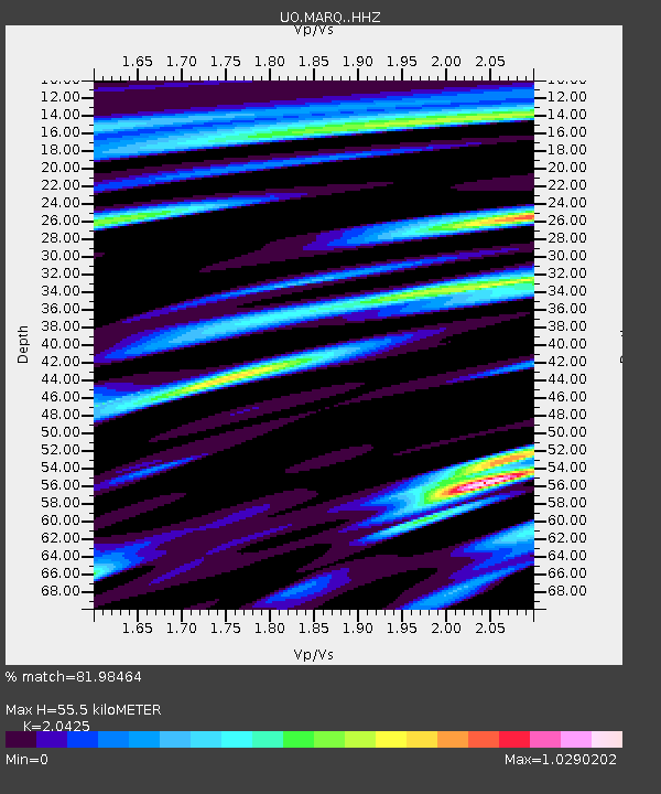
| Estimated Moho Depth: |
55.5 km |
| Estimated Crust Vp/Vs: |
2.04 |
| Assumed Crust Vp: |
6.566 km/s |
| Estimated Crust Vs: |
3.215 km/s |
| Estimated Crust Poisson's Ratio: |
0.34 |
|
| Radial Match: |
81.98464 % |
| Radial Bump: |
400 |
| Transverse Match: |
71.372 % |
| Transverse Bump: |
400 |
| SOD ConfigId: |
13570011 |
| Insert Time: |
2019-05-02 11:18:53.563 +0000 |
| GWidth: |
2.5 |
| Max Bumps: |
400 |
| Tol: |
0.001 |
|

Signal To Noise
| Channel | StoN | STA | LTA |
| UO:MARQ: :HHZ:20190201T16:21:07.769993Z | 13.675278 | 4.459872E-6 | 3.261266E-7 |
| UO:MARQ: :HHN:20190201T16:21:07.769993Z | 5.5758348 | 1.6248371E-6 | 2.9140696E-7 |
| UO:MARQ: :HHE:20190201T16:21:07.769993Z | 6.3907433 | 1.9376223E-6 | 3.0319202E-7 |
| Arrivals |
| Ps | 9.4 SECOND |
| PpPs | 24 SECOND |
| PsPs/PpSs | 34 SECOND |


