You are here: Home > Network List > UW - Pacific Northwest Regional Seismic Network Stations List
> Station KREP White Salmon, WA, USA > Earthquake Result Viewer
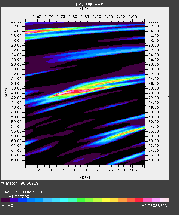
KREP White Salmon, WA, USA - Earthquake Result Viewer
| Earthquake location: |
Near Coast Of Chiapas, Mexico |
| Earthquake latitude/longitude: |
14.8/-92.3 |
| Earthquake time(UTC): |
2019/02/01 (032) 16:14:13 GMT |
| Earthquake Depth: |
68 km |
| Earthquake Magnitude: |
6.6 Mww |
| Earthquake Catalog/Contributor: |
NEIC PDE/us |
|
| Network: |
UW Pacific Northwest Regional Seismic Network |
| Station: |
KREP White Salmon, WA, USA |
| Lat/Lon: |
45.89 N/121.46 W |
| Elevation: |
472 m |
|
| Distance: |
39.5 deg |
| Az: |
327.672 deg |
| Baz: |
132.215 deg |
| Ray Param: |
0.07472665 |
| Estimated Moho Depth: |
40.0 km |
| Estimated Crust Vp/Vs: |
1.75 |
| Assumed Crust Vp: |
6.597 km/s |
| Estimated Crust Vs: |
3.775 km/s |
| Estimated Crust Poisson's Ratio: |
0.26 |
|
| Radial Match: |
90.50959 % |
| Radial Bump: |
400 |
| Transverse Match: |
82.922485 % |
| Transverse Bump: |
400 |
| SOD ConfigId: |
13570011 |
| Insert Time: |
2019-05-02 11:19:18.065 +0000 |
| GWidth: |
2.5 |
| Max Bumps: |
400 |
| Tol: |
0.001 |
|

Signal To Noise
| Channel | StoN | STA | LTA |
| UW:KREP: :HHZ:20190201T16:21:06.910007Z | 30.071835 | 9.680871E-6 | 3.2192486E-7 |
| UW:KREP: :HHN:20190201T16:21:06.910007Z | 5.693266 | 3.2827286E-6 | 5.765985E-7 |
| UW:KREP: :HHE:20190201T16:21:06.910007Z | 7.612393 | 2.6945097E-6 | 3.5396354E-7 |
| Arrivals |
| Ps | 4.9 SECOND |
| PpPs | 15 SECOND |
| PsPs/PpSs | 20 SECOND |


