You are here: Home > Network List > TA - USArray Transportable Network (new EarthScope stations) Stations List
> Station F22A Rosebud, MT, USA > Earthquake Result Viewer
F22A Rosebud, MT, USA - Earthquake Result Viewer
| Earthquake location: |
Kyushu, Japan |
| Earthquake latitude/longitude: |
31.1/130.0 |
| Earthquake time(UTC): |
2009/09/03 (246) 13:26:18 GMT |
| Earthquake Depth: |
166 km |
| Earthquake Magnitude: |
5.9 MB, 6.2 MW, 6.2 MW |
| Earthquake Catalog/Contributor: |
WHDF/NEIC |
|
| Network: |
TA USArray Transportable Network (new EarthScope stations) |
| Station: |
F22A Rosebud, MT, USA |
| Lat/Lon: |
45.78 N/106.26 W |
| Elevation: |
882 m |
|
| Distance: |
88.0 deg |
| Az: |
35.622 deg |
| Baz: |
314.471 deg |
| Ray Param: |
0.042519353 |
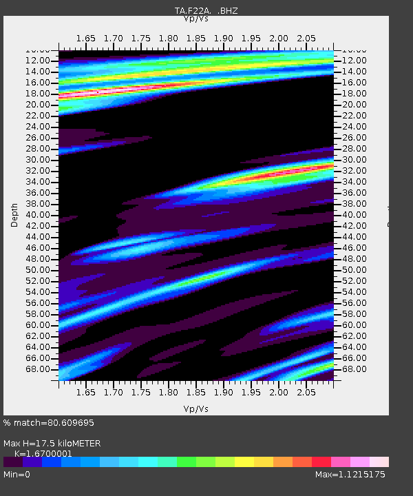
| Estimated Moho Depth: |
17.5 km |
| Estimated Crust Vp/Vs: |
1.67 |
| Assumed Crust Vp: |
6.178 km/s |
| Estimated Crust Vs: |
3.7 km/s |
| Estimated Crust Poisson's Ratio: |
0.22 |
|
| Radial Match: |
80.609695 % |
| Radial Bump: |
400 |
| Transverse Match: |
64.40288 % |
| Transverse Bump: |
389 |
| SOD ConfigId: |
2622 |
| Insert Time: |
2010-03-06 19:55:36.927 +0000 |
| GWidth: |
2.5 |
| Max Bumps: |
400 |
| Tol: |
0.001 |
|

Signal To Noise
| Channel | StoN | STA | LTA |
| TA:F22A: :BHZ:20090903T13:38:18.450022Z | 13.679561 | 1.4428891E-6 | 1.0547774E-7 |
| TA:F22A: :BHN:20090903T13:38:18.450022Z | 2.3240182 | 3.7082225E-7 | 1.5956081E-7 |
| TA:F22A: :BHE:20090903T13:38:18.450022Z | 1.6660453 | 3.3577024E-7 | 2.0153728E-7 |
| Arrivals |
| Ps | 1.9 SECOND |
| PpPs | 7.4 SECOND |
| PsPs/PpSs | 9.3 SECOND |


