You are here: Home > Network List > TA - USArray Transportable Network (new EarthScope stations) Stations List
> Station F22A Rosebud, MT, USA > Earthquake Result Viewer
F22A Rosebud, MT, USA - Earthquake Result Viewer
| Earthquake location: |
Northern Mid-Atlantic Ridge |
| Earthquake latitude/longitude: |
23.9/-46.1 |
| Earthquake time(UTC): |
2009/06/06 (157) 20:33:28 GMT |
| Earthquake Depth: |
14 km |
| Earthquake Magnitude: |
6.0 MB, 5.7 MS, 6.0 MW, 6.0 MW |
| Earthquake Catalog/Contributor: |
WHDF/NEIC |
|
| Network: |
TA USArray Transportable Network (new EarthScope stations) |
| Station: |
F22A Rosebud, MT, USA |
| Lat/Lon: |
45.78 N/106.26 W |
| Elevation: |
882 m |
|
| Distance: |
52.7 deg |
| Az: |
310.249 deg |
| Baz: |
93.167 deg |
| Ray Param: |
0.066593915 |
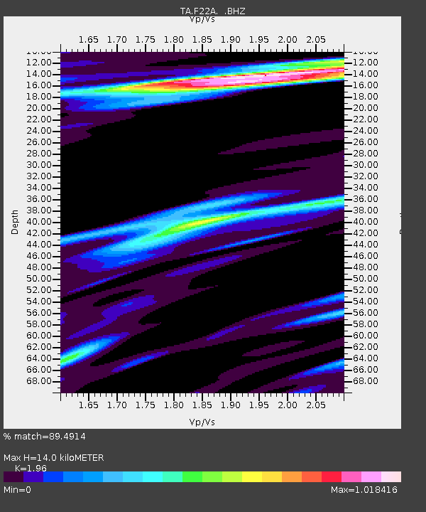
| Estimated Moho Depth: |
14.0 km |
| Estimated Crust Vp/Vs: |
1.96 |
| Assumed Crust Vp: |
6.178 km/s |
| Estimated Crust Vs: |
3.152 km/s |
| Estimated Crust Poisson's Ratio: |
0.32 |
|
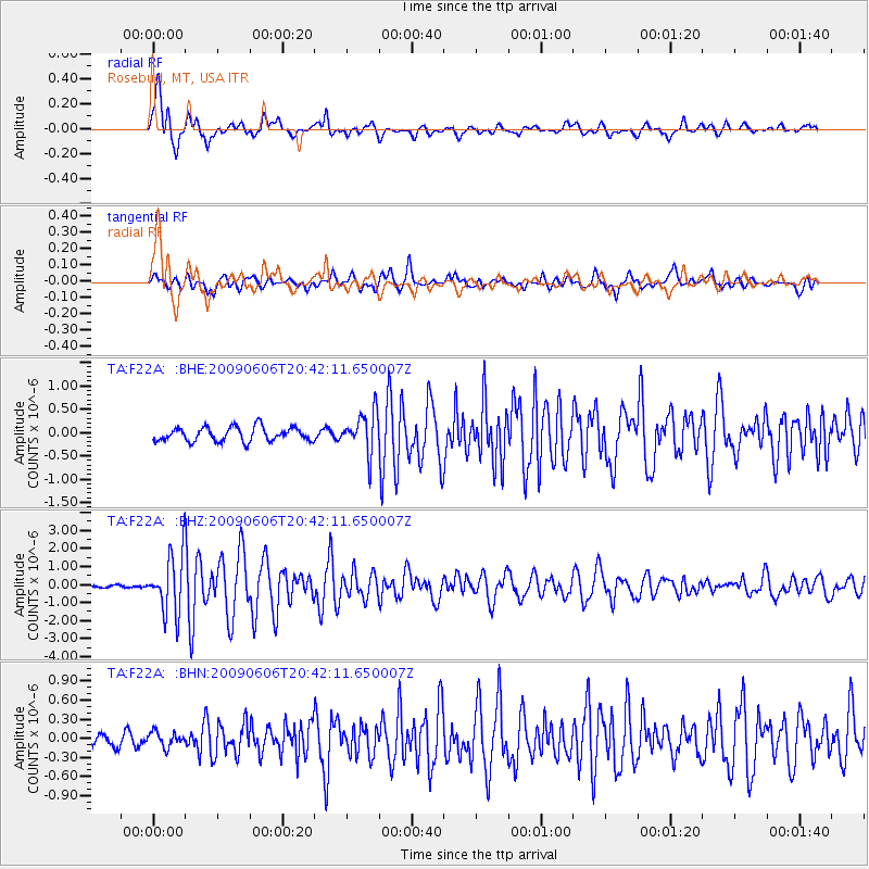
| Radial Match: |
89.4914 % |
| Radial Bump: |
400 |
| Transverse Match: |
78.27439 % |
| Transverse Bump: |
400 |
| SOD ConfigId: |
2648 |
| Insert Time: |
2010-03-06 19:55:56.290 +0000 |
| GWidth: |
2.5 |
| Max Bumps: |
400 |
| Tol: |
0.001 |
|
Signal To Noise
| Channel | StoN | STA | LTA |
| TA:F22A: :BHZ:20090606T20:42:11.650007Z | 20.104876 | 1.606065E-6 | 7.988436E-8 |
| TA:F22A: :BHN:20090606T20:42:11.650007Z | 1.5181711 | 1.17707735E-7 | 7.753259E-8 |
| TA:F22A: :BHE:20090606T20:42:11.650007Z | 2.8949332 | 4.3491093E-7 | 1.5023176E-7 |
| Arrivals |
| Ps | 2.3 SECOND |
| PpPs | 6.4 SECOND |
| PsPs/PpSs | 8.7 SECOND |


