You are here: Home > Network List > TA - USArray Transportable Network (new EarthScope stations) Stations List
> Station F22A Rosebud, MT, USA > Earthquake Result Viewer
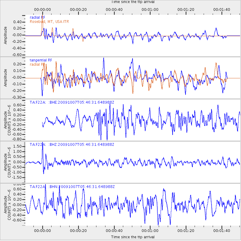
F22A Rosebud, MT, USA - Earthquake Result Viewer
*The percent match for this event was below the threshold and hence no stack was calculated.
| Earthquake location: |
Rat Islands, Aleutian Islands |
| Earthquake latitude/longitude: |
52.2/178.1 |
| Earthquake time(UTC): |
2009/10/07 (280) 05:38:37 GMT |
| Earthquake Depth: |
138 km |
| Earthquake Magnitude: |
5.6 MB, 5.6 MW, 5.6 MW |
| Earthquake Catalog/Contributor: |
WHDF/NEIC |
|
| Network: |
TA USArray Transportable Network (new EarthScope stations) |
| Station: |
F22A Rosebud, MT, USA |
| Lat/Lon: |
45.78 N/106.26 W |
| Elevation: |
882 m |
|
| Distance: |
48.0 deg |
| Az: |
65.865 deg |
| Baz: |
306.547 deg |
| Ray Param: |
$rayparam |
*The percent match for this event was below the threshold and hence was not used in the summary stack. |
|
| Radial Match: |
42.187508 % |
| Radial Bump: |
400 |
| Transverse Match: |
49.850933 % |
| Transverse Bump: |
400 |
| SOD ConfigId: |
2622 |
| Insert Time: |
2010-03-06 19:56:27.298 +0000 |
| GWidth: |
2.5 |
| Max Bumps: |
400 |
| Tol: |
0.001 |
|
Signal To Noise
| Channel | StoN | STA | LTA |
| TA:F22A: :BHZ:20091007T05:46:31.648988Z | 5.8647857 | 6.31071E-7 | 1.0760341E-7 |
| TA:F22A: :BHN:20091007T05:46:31.648988Z | 1.3518214 | 2.6824947E-7 | 1.9843557E-7 |
| TA:F22A: :BHE:20091007T05:46:31.648988Z | 1.8065473 | 3.0210157E-7 | 1.6722593E-7 |
| Arrivals |
| Ps | |
| PpPs | |
| PsPs/PpSs | |


