You are here: Home > Network List > US - United States National Seismic Network Stations List
> Station AMTX Amarillo, Texas, USA > Earthquake Result Viewer
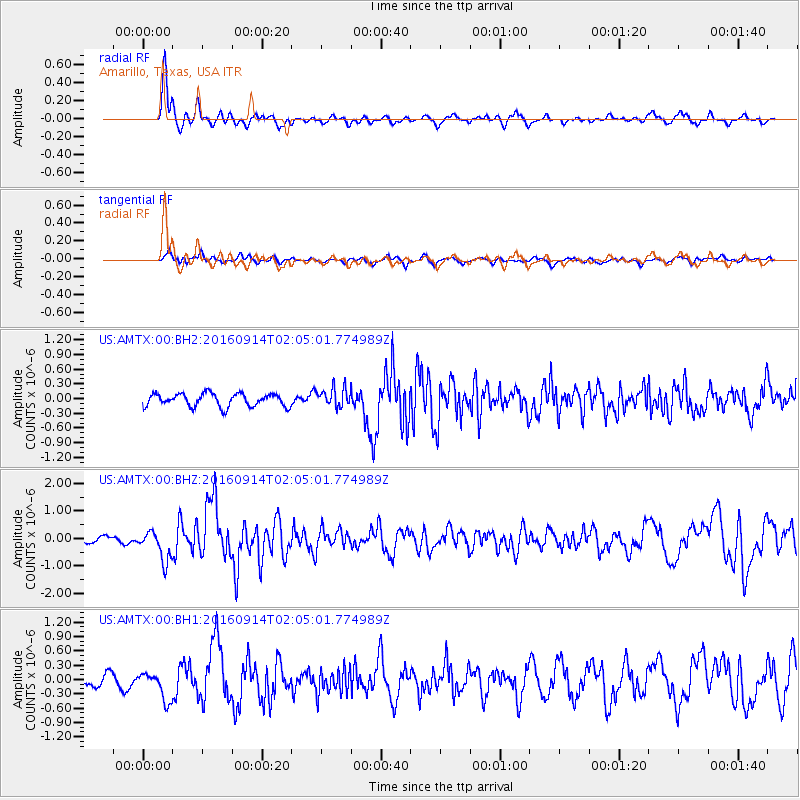
AMTX Amarillo, Texas, USA - Earthquake Result Viewer
*The percent match for this event was below the threshold and hence no stack was calculated.
| Earthquake location: |
Northern Colombia |
| Earthquake latitude/longitude: |
7.3/-76.1 |
| Earthquake time(UTC): |
2016/09/14 (258) 01:58:30 GMT |
| Earthquake Depth: |
10 km |
| Earthquake Magnitude: |
5.9 MWP |
| Earthquake Catalog/Contributor: |
NEIC PDE/NEIC COMCAT |
|
| Network: |
US United States National Seismic Network |
| Station: |
AMTX Amarillo, Texas, USA |
| Lat/Lon: |
34.53 N/101.41 W |
| Elevation: |
1010 m |
|
| Distance: |
35.7 deg |
| Az: |
322.81 deg |
| Baz: |
133.427 deg |
| Ray Param: |
$rayparam |
*The percent match for this event was below the threshold and hence was not used in the summary stack. |
|
| Radial Match: |
87.10342 % |
| Radial Bump: |
369 |
| Transverse Match: |
63.623856 % |
| Transverse Bump: |
400 |
| SOD ConfigId: |
1634031 |
| Insert Time: |
2016-09-28 02:01:51.742 +0000 |
| GWidth: |
2.5 |
| Max Bumps: |
400 |
| Tol: |
0.001 |
|
Signal To Noise
| Channel | StoN | STA | LTA |
| US:AMTX:00:BHZ:20160914T02:05:01.774989Z | 3.7821598 | 5.427845E-7 | 1.4351178E-7 |
| US:AMTX:00:BH1:20160914T02:05:01.774989Z | 2.688475 | 3.0622965E-7 | 1.139046E-7 |
| US:AMTX:00:BH2:20160914T02:05:01.774989Z | 0.85715115 | 1.1274042E-7 | 1.3152922E-7 |
| Arrivals |
| Ps | |
| PpPs | |
| PsPs/PpSs | |


