You are here: Home > Network List > TA - USArray Transportable Network (new EarthScope stations) Stations List
> Station P08K Saint George Island, AK, USA > Earthquake Result Viewer
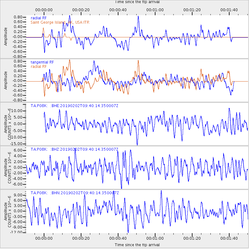
P08K Saint George Island, AK, USA - Earthquake Result Viewer
*The percent match for this event was below the threshold and hence no stack was calculated.
| Earthquake location: |
Southern Sumatra, Indonesia |
| Earthquake latitude/longitude: |
-2.9/100.0 |
| Earthquake time(UTC): |
2019/02/02 (033) 09:27:34 GMT |
| Earthquake Depth: |
10 km |
| Earthquake Magnitude: |
6.1 Mww |
| Earthquake Catalog/Contributor: |
NEIC PDE/us |
|
| Network: |
TA USArray Transportable Network (new EarthScope stations) |
| Station: |
P08K Saint George Island, AK, USA |
| Lat/Lon: |
56.60 N/169.55 W |
| Elevation: |
36 m |
|
| Distance: |
92.6 deg |
| Az: |
33.614 deg |
| Baz: |
268.786 deg |
| Ray Param: |
$rayparam |
*The percent match for this event was below the threshold and hence was not used in the summary stack. |
|
| Radial Match: |
43.674145 % |
| Radial Bump: |
400 |
| Transverse Match: |
39.269936 % |
| Transverse Bump: |
400 |
| SOD ConfigId: |
13570011 |
| Insert Time: |
2019-05-02 11:36:39.110 +0000 |
| GWidth: |
2.5 |
| Max Bumps: |
400 |
| Tol: |
0.001 |
|
Signal To Noise
| Channel | StoN | STA | LTA |
| TA:P08K: :BHZ:20190202T09:40:14.350007Z | 0.82181025 | 1.9354238E-6 | 2.355074E-6 |
| TA:P08K: :BHN:20190202T09:40:14.350007Z | 1.1755666 | 4.739566E-6 | 4.0317295E-6 |
| TA:P08K: :BHE:20190202T09:40:14.350007Z | 0.97755456 | 3.382307E-6 | 3.4599675E-6 |
| Arrivals |
| Ps | |
| PpPs | |
| PsPs/PpSs | |


