You are here: Home > Network List > TJ - Tajikistan National Seismic Network Stations List
> Station MANEM Manem, Tajikistan > Earthquake Result Viewer
MANEM Manem, Tajikistan - Earthquake Result Viewer
| Earthquake location: |
Southern Sumatra, Indonesia |
| Earthquake latitude/longitude: |
-2.9/100.0 |
| Earthquake time(UTC): |
2019/02/02 (033) 09:27:34 GMT |
| Earthquake Depth: |
10 km |
| Earthquake Magnitude: |
6.1 Mww |
| Earthquake Catalog/Contributor: |
NEIC PDE/us |
|
| Network: |
TJ Tajikistan National Seismic Network |
| Station: |
MANEM Manem, Tajikistan |
| Lat/Lon: |
37.53 N/71.66 E |
| Elevation: |
2312 m |
|
| Distance: |
48.0 deg |
| Az: |
329.477 deg |
| Baz: |
140.353 deg |
| Ray Param: |
0.069613315 |
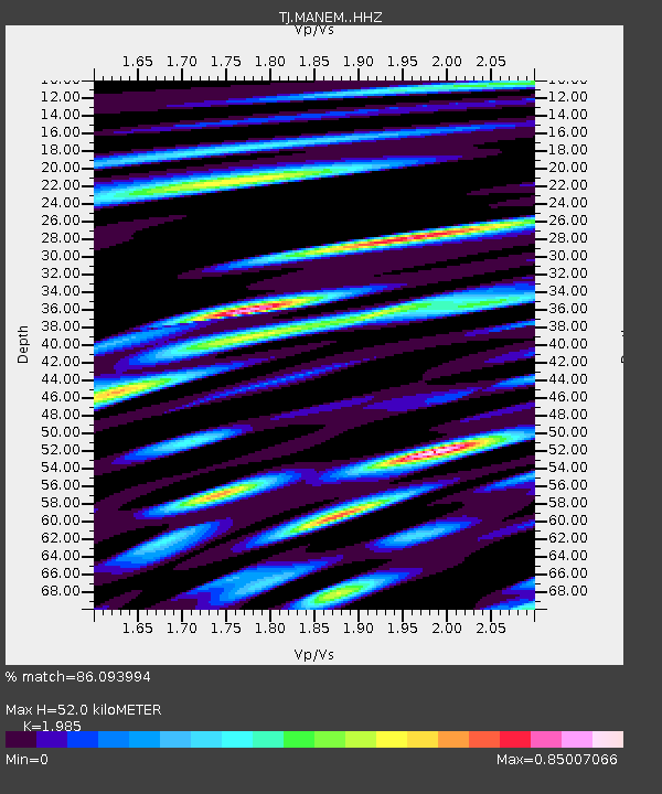
| Estimated Moho Depth: |
52.0 km |
| Estimated Crust Vp/Vs: |
1.99 |
| Assumed Crust Vp: |
6.306 km/s |
| Estimated Crust Vs: |
3.177 km/s |
| Estimated Crust Poisson's Ratio: |
0.33 |
|
| Radial Match: |
86.093994 % |
| Radial Bump: |
400 |
| Transverse Match: |
83.38062 % |
| Transverse Bump: |
400 |
| SOD ConfigId: |
13570011 |
| Insert Time: |
2019-05-02 11:36:40.376 +0000 |
| GWidth: |
2.5 |
| Max Bumps: |
400 |
| Tol: |
0.001 |
|

Signal To Noise
| Channel | StoN | STA | LTA |
| TJ:MANEM: :HHZ:20190202T09:35:43.070009Z | 9.91509 | 2.8423617E-6 | 2.866703E-7 |
| TJ:MANEM: :HHN:20190202T09:35:43.070009Z | 8.3534 | 9.328838E-7 | 1.1167713E-7 |
| TJ:MANEM: :HHE:20190202T09:35:43.070009Z | 5.09557 | 1.0215412E-6 | 2.0047632E-7 |
| Arrivals |
| Ps | 8.6 SECOND |
| PpPs | 23 SECOND |
| PsPs/PpSs | 32 SECOND |


