You are here: Home > Network List > TA - USArray Transportable Network (new EarthScope stations) Stations List
> Station L25A Engebretsen Ranch, Morrill, NE, USA > Earthquake Result Viewer
L25A Engebretsen Ranch, Morrill, NE, USA - Earthquake Result Viewer
| Earthquake location: |
Near Coast Of Venezuela |
| Earthquake latitude/longitude: |
10.7/-67.9 |
| Earthquake time(UTC): |
2009/09/12 (255) 20:06:24 GMT |
| Earthquake Depth: |
10 km |
| Earthquake Magnitude: |
6.3 MB, 6.4 MS, 6.3 MW, 6.3 MW |
| Earthquake Catalog/Contributor: |
WHDF/NEIC |
|
| Network: |
TA USArray Transportable Network (new EarthScope stations) |
| Station: |
L25A Engebretsen Ranch, Morrill, NE, USA |
| Lat/Lon: |
42.15 N/103.97 W |
| Elevation: |
1379 m |
|
| Distance: |
44.4 deg |
| Az: |
321.304 deg |
| Baz: |
124.274 deg |
| Ray Param: |
0.07193063 |
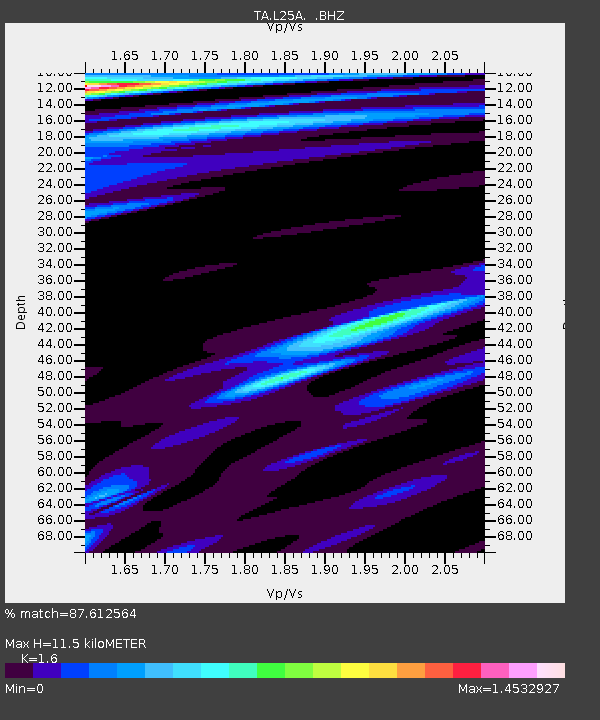
| Estimated Moho Depth: |
11.5 km |
| Estimated Crust Vp/Vs: |
1.60 |
| Assumed Crust Vp: |
6.483 km/s |
| Estimated Crust Vs: |
4.052 km/s |
| Estimated Crust Poisson's Ratio: |
0.18 |
|
| Radial Match: |
87.612564 % |
| Radial Bump: |
340 |
| Transverse Match: |
69.33431 % |
| Transverse Bump: |
400 |
| SOD ConfigId: |
2622 |
| Insert Time: |
2010-03-06 19:57:15.880 +0000 |
| GWidth: |
2.5 |
| Max Bumps: |
400 |
| Tol: |
0.001 |
|
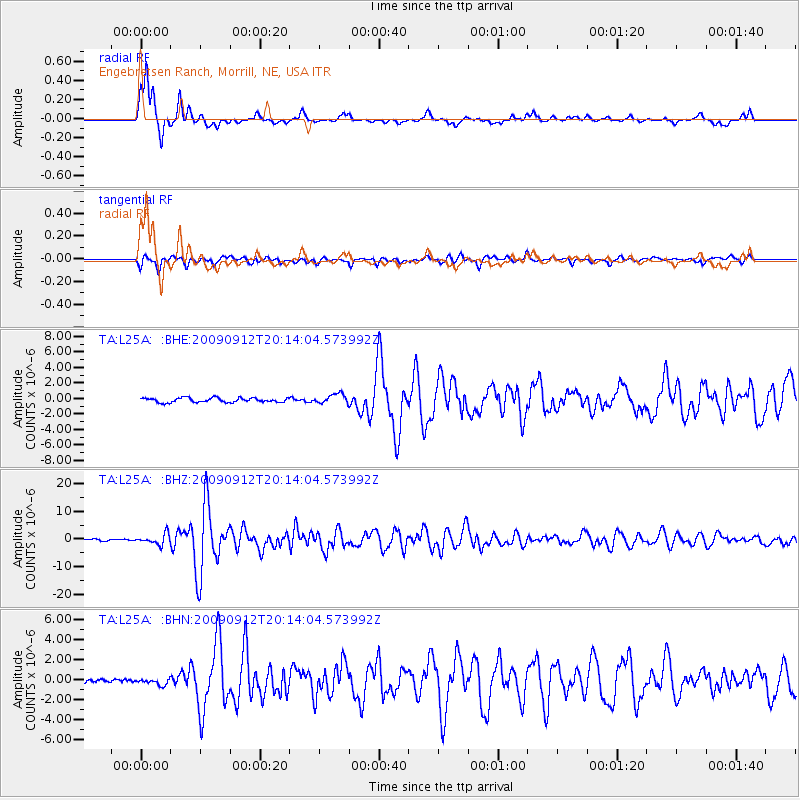
Signal To Noise
| Channel | StoN | STA | LTA |
| TA:L25A: :BHZ:20090912T20:14:04.573992Z | 9.323455 | 1.8828642E-6 | 2.019492E-7 |
| TA:L25A: :BHN:20090912T20:14:04.573992Z | 1.6319621 | 3.089534E-7 | 1.8931408E-7 |
| TA:L25A: :BHE:20090912T20:14:04.573992Z | 2.1906645 | 6.231741E-7 | 2.844681E-7 |
| Arrivals |
| Ps | 1.1 SECOND |
| PpPs | 4.3 SECOND |
| PsPs/PpSs | 5.4 SECOND |


