You are here: Home > Network List > TA - USArray Transportable Network (new EarthScope stations) Stations List
> Station L25A Engebretsen Ranch, Morrill, NE, USA > Earthquake Result Viewer
L25A Engebretsen Ranch, Morrill, NE, USA - Earthquake Result Viewer
| Earthquake location: |
Hokkaido, Japan Region |
| Earthquake latitude/longitude: |
41.8/143.4 |
| Earthquake time(UTC): |
2009/06/05 (156) 03:30:33 GMT |
| Earthquake Depth: |
29 km |
| Earthquake Magnitude: |
6.0 MB, 6.3 MS, 6.4 MW, 6.4 MW |
| Earthquake Catalog/Contributor: |
WHDF/NEIC |
|
| Network: |
TA USArray Transportable Network (new EarthScope stations) |
| Station: |
L25A Engebretsen Ranch, Morrill, NE, USA |
| Lat/Lon: |
42.15 N/103.97 W |
| Elevation: |
1379 m |
|
| Distance: |
76.7 deg |
| Az: |
44.875 deg |
| Baz: |
314.829 deg |
| Ray Param: |
0.05080784 |
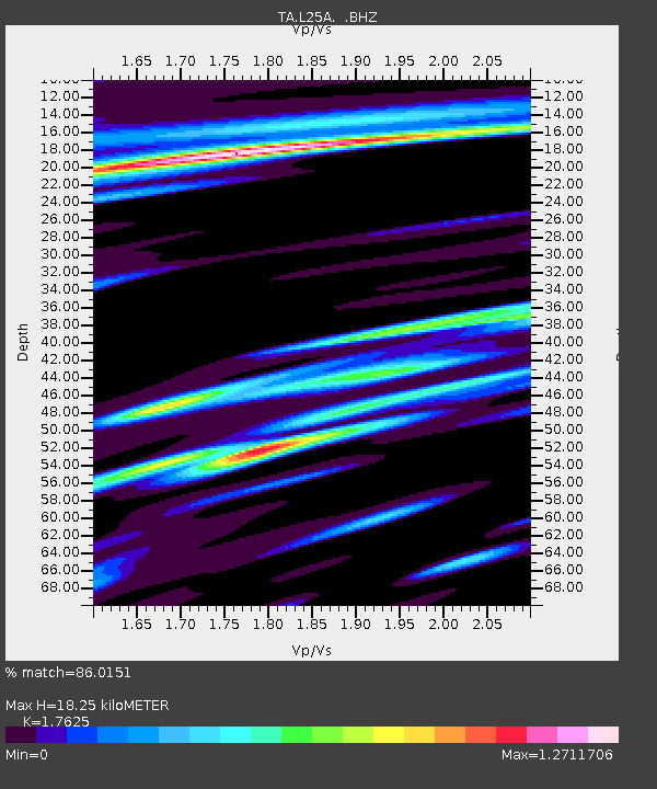
| Estimated Moho Depth: |
18.25 km |
| Estimated Crust Vp/Vs: |
1.76 |
| Assumed Crust Vp: |
6.483 km/s |
| Estimated Crust Vs: |
3.678 km/s |
| Estimated Crust Poisson's Ratio: |
0.26 |
|
| Radial Match: |
86.0151 % |
| Radial Bump: |
400 |
| Transverse Match: |
64.818924 % |
| Transverse Bump: |
400 |
| SOD ConfigId: |
2648 |
| Insert Time: |
2010-03-06 19:57:24.288 +0000 |
| GWidth: |
2.5 |
| Max Bumps: |
400 |
| Tol: |
0.001 |
|
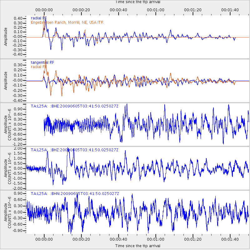
Signal To Noise
| Channel | StoN | STA | LTA |
| TA:L25A: :BHZ:20090605T03:41:50.025027Z | 4.4119797 | 7.0265264E-7 | 1.5926017E-7 |
| TA:L25A: :BHN:20090605T03:41:50.025027Z | 0.99663997 | 2.2936389E-7 | 2.3013718E-7 |
| TA:L25A: :BHE:20090605T03:41:50.025027Z | 1.0944773 | 2.4720956E-7 | 2.2586995E-7 |
| Arrivals |
| Ps | 2.2 SECOND |
| PpPs | 7.5 SECOND |
| PsPs/PpSs | 9.7 SECOND |


