You are here: Home > Network List > TA - USArray Transportable Network (new EarthScope stations) Stations List
> Station L25A Engebretsen Ranch, Morrill, NE, USA > Earthquake Result Viewer
L25A Engebretsen Ranch, Morrill, NE, USA - Earthquake Result Viewer
| Earthquake location: |
North Of Svalbard |
| Earthquake latitude/longitude: |
80.3/-1.9 |
| Earthquake time(UTC): |
2009/03/06 (065) 10:50:29 GMT |
| Earthquake Depth: |
9.0 km |
| Earthquake Magnitude: |
6.6 MB, 6.5 MS, 6.5 MW, 6.4 MW |
| Earthquake Catalog/Contributor: |
WHDF/NEIC |
|
| Network: |
TA USArray Transportable Network (new EarthScope stations) |
| Station: |
L25A Engebretsen Ranch, Morrill, NE, USA |
| Lat/Lon: |
42.15 N/103.97 W |
| Elevation: |
1379 m |
|
| Distance: |
50.8 deg |
| Az: |
290.159 deg |
| Baz: |
12.332 deg |
| Ray Param: |
0.06784464 |
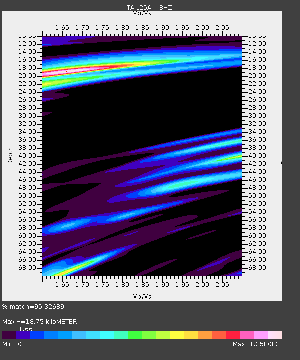
| Estimated Moho Depth: |
18.75 km |
| Estimated Crust Vp/Vs: |
1.66 |
| Assumed Crust Vp: |
6.483 km/s |
| Estimated Crust Vs: |
3.905 km/s |
| Estimated Crust Poisson's Ratio: |
0.22 |
|
| Radial Match: |
95.32689 % |
| Radial Bump: |
400 |
| Transverse Match: |
86.27215 % |
| Transverse Bump: |
400 |
| SOD ConfigId: |
2658 |
| Insert Time: |
2010-03-06 19:57:25.895 +0000 |
| GWidth: |
2.5 |
| Max Bumps: |
400 |
| Tol: |
0.001 |
|
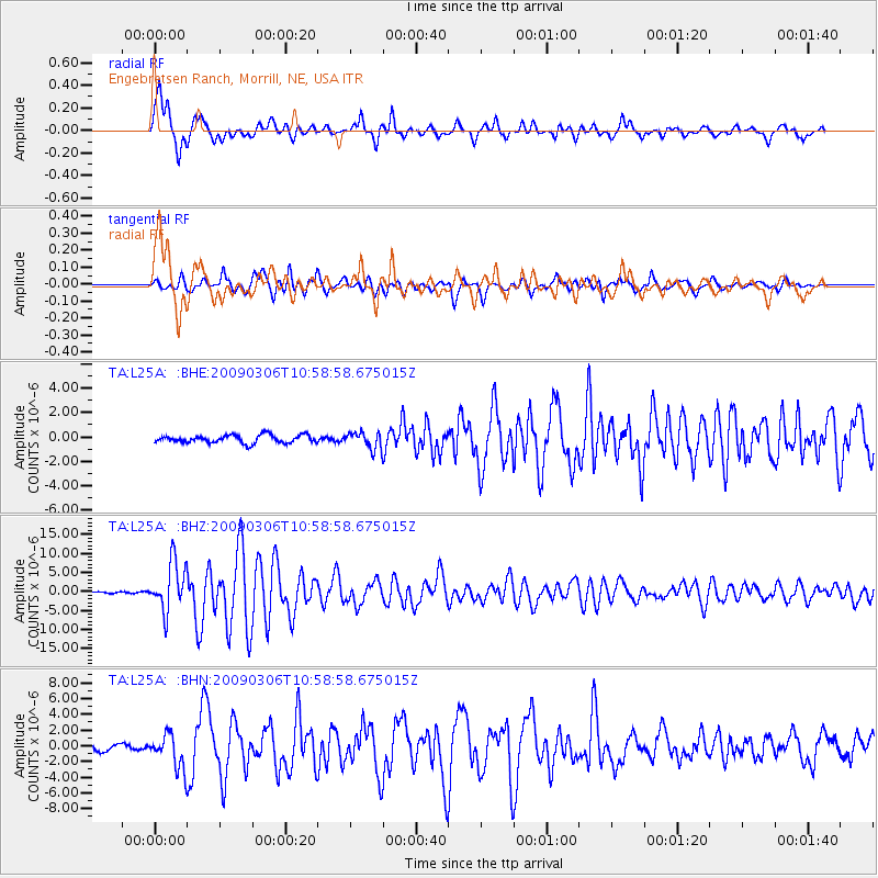
Signal To Noise
| Channel | StoN | STA | LTA |
| TA:L25A: :BHZ:20090306T10:58:58.675015Z | 37.676395 | 6.296046E-6 | 1.6710851E-7 |
| TA:L25A: :BHN:20090306T10:58:58.675015Z | 5.306503 | 2.1501403E-6 | 4.0518972E-7 |
| TA:L25A: :BHE:20090306T10:58:58.675015Z | 2.141861 | 6.8913863E-7 | 3.2174762E-7 |
| Arrivals |
| Ps | 2.0 SECOND |
| PpPs | 7.2 SECOND |
| PsPs/PpSs | 9.3 SECOND |


