You are here: Home > Network List > TA - USArray Transportable Network (new EarthScope stations) Stations List
> Station B18K Kokolik River, AK, USA > Earthquake Result Viewer
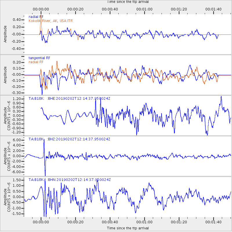
B18K Kokolik River, AK, USA - Earthquake Result Viewer
*The percent match for this event was below the threshold and hence no stack was calculated.
| Earthquake location: |
Hindu Kush Region, Afghanistan |
| Earthquake latitude/longitude: |
36.5/70.7 |
| Earthquake time(UTC): |
2019/02/02 (033) 12:04:34 GMT |
| Earthquake Depth: |
211 km |
| Earthquake Magnitude: |
5.6 Mww |
| Earthquake Catalog/Contributor: |
NEIC PDE/us |
|
| Network: |
TA USArray Transportable Network (new EarthScope stations) |
| Station: |
B18K Kokolik River, AK, USA |
| Lat/Lon: |
69.36 N/161.80 W |
| Elevation: |
222 m |
|
| Distance: |
67.7 deg |
| Az: |
17.699 deg |
| Baz: |
316.287 deg |
| Ray Param: |
$rayparam |
*The percent match for this event was below the threshold and hence was not used in the summary stack. |
|
| Radial Match: |
62.01858 % |
| Radial Bump: |
400 |
| Transverse Match: |
42.39751 % |
| Transverse Bump: |
400 |
| SOD ConfigId: |
13570011 |
| Insert Time: |
2019-05-02 11:46:41.484 +0000 |
| GWidth: |
2.5 |
| Max Bumps: |
400 |
| Tol: |
0.001 |
|
Signal To Noise
| Channel | StoN | STA | LTA |
| TA:B18K: :BHZ:20190202T12:14:37.950024Z | 6.548644 | 2.4277567E-6 | 3.7072664E-7 |
| TA:B18K: :BHN:20190202T12:14:37.950024Z | 4.660569 | 8.730137E-7 | 1.8731913E-7 |
| TA:B18K: :BHE:20190202T12:14:37.950024Z | 1.9745774 | 4.8140544E-7 | 2.4380174E-7 |
| Arrivals |
| Ps | |
| PpPs | |
| PsPs/PpSs | |


