You are here: Home > Network List > TA - USArray Transportable Network (new EarthScope stations) Stations List
> Station F21K Alatna River, AK, USA > Earthquake Result Viewer
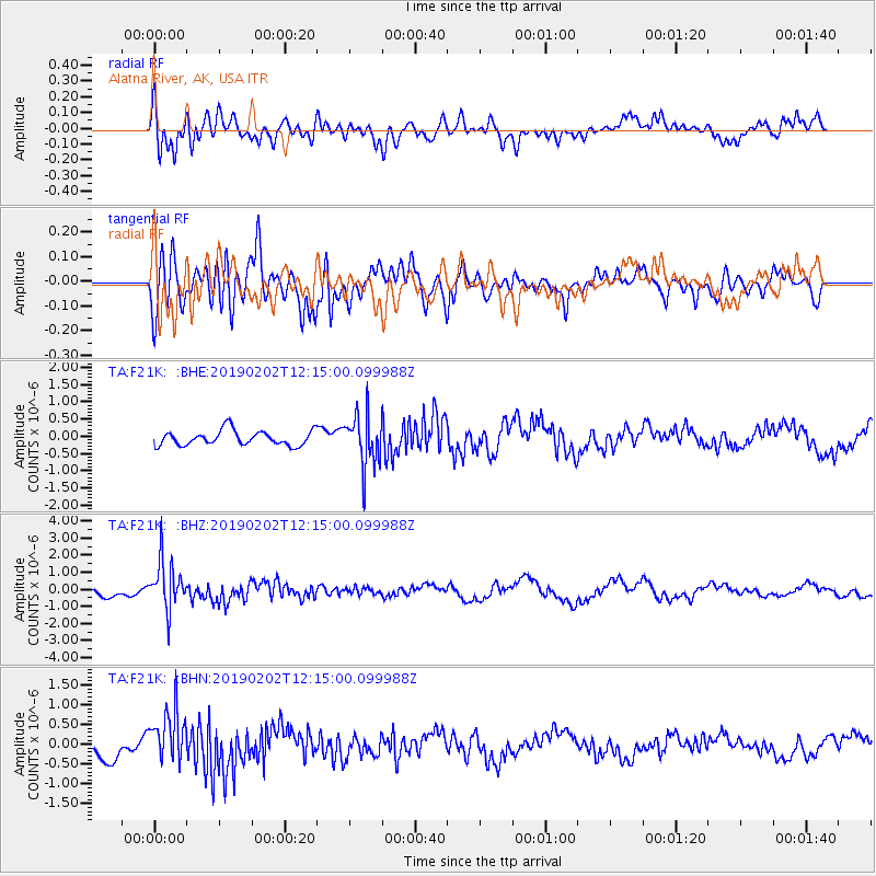
F21K Alatna River, AK, USA - Earthquake Result Viewer
*The percent match for this event was below the threshold and hence no stack was calculated.
| Earthquake location: |
Hindu Kush Region, Afghanistan |
| Earthquake latitude/longitude: |
36.5/70.7 |
| Earthquake time(UTC): |
2019/02/02 (033) 12:04:34 GMT |
| Earthquake Depth: |
211 km |
| Earthquake Magnitude: |
5.6 Mww |
| Earthquake Catalog/Contributor: |
NEIC PDE/us |
|
| Network: |
TA USArray Transportable Network (new EarthScope stations) |
| Station: |
F21K Alatna River, AK, USA |
| Lat/Lon: |
67.22 N/153.48 W |
| Elevation: |
597 m |
|
| Distance: |
71.3 deg |
| Az: |
16.646 deg |
| Baz: |
323.642 deg |
| Ray Param: |
$rayparam |
*The percent match for this event was below the threshold and hence was not used in the summary stack. |
|
| Radial Match: |
73.26957 % |
| Radial Bump: |
400 |
| Transverse Match: |
73.21819 % |
| Transverse Bump: |
400 |
| SOD ConfigId: |
13570011 |
| Insert Time: |
2019-05-02 11:47:07.446 +0000 |
| GWidth: |
2.5 |
| Max Bumps: |
400 |
| Tol: |
0.001 |
|
Signal To Noise
| Channel | StoN | STA | LTA |
| TA:F21K: :BHZ:20190202T12:15:00.099988Z | 8.687684 | 1.405451E-6 | 1.617751E-7 |
| TA:F21K: :BHN:20190202T12:15:00.099988Z | 3.0052538 | 6.552192E-7 | 2.1802458E-7 |
| TA:F21K: :BHE:20190202T12:15:00.099988Z | 3.501691 | 7.437093E-7 | 2.1238574E-7 |
| Arrivals |
| Ps | |
| PpPs | |
| PsPs/PpSs | |


