You are here: Home > Network List > TA - USArray Transportable Network (new EarthScope stations) Stations List
> Station R26A Arlington, CO, USA > Earthquake Result Viewer
R26A Arlington, CO, USA - Earthquake Result Viewer
| Earthquake location: |
Off Coast Of Costa Rica |
| Earthquake latitude/longitude: |
7.9/-85.6 |
| Earthquake time(UTC): |
2009/08/13 (225) 09:37:35 GMT |
| Earthquake Depth: |
10 km |
| Earthquake Magnitude: |
5.8 MW, 5.3 MB |
| Earthquake Catalog/Contributor: |
WHDF/NEIC |
|
| Network: |
TA USArray Transportable Network (new EarthScope stations) |
| Station: |
R26A Arlington, CO, USA |
| Lat/Lon: |
38.30 N/103.45 W |
| Elevation: |
1304 m |
|
| Distance: |
34.2 deg |
| Az: |
334.668 deg |
| Baz: |
147.408 deg |
| Ray Param: |
0.07784109 |
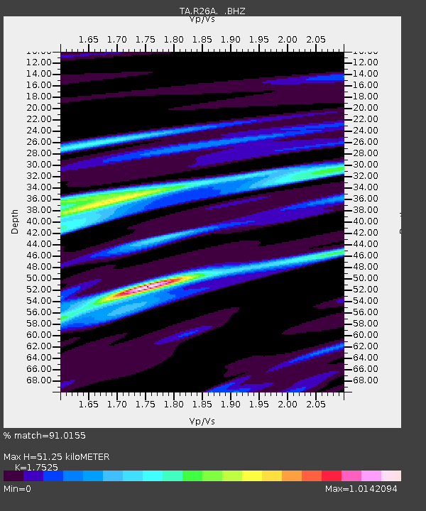
| Estimated Moho Depth: |
51.25 km |
| Estimated Crust Vp/Vs: |
1.75 |
| Assumed Crust Vp: |
6.242 km/s |
| Estimated Crust Vs: |
3.562 km/s |
| Estimated Crust Poisson's Ratio: |
0.26 |
|
| Radial Match: |
91.0155 % |
| Radial Bump: |
307 |
| Transverse Match: |
68.84916 % |
| Transverse Bump: |
400 |
| SOD ConfigId: |
2622 |
| Insert Time: |
2010-03-06 19:59:00.022 +0000 |
| GWidth: |
2.5 |
| Max Bumps: |
400 |
| Tol: |
0.001 |
|
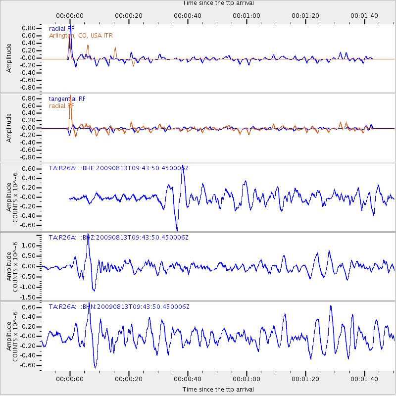
Signal To Noise
| Channel | StoN | STA | LTA |
| TA:R26A: :BHZ:20090813T09:43:50.450006Z | 4.4132633 | 2.9201203E-7 | 6.616692E-8 |
| TA:R26A: :BHN:20090813T09:43:50.450006Z | 2.025858 | 1.3715949E-7 | 6.77044E-8 |
| TA:R26A: :BHE:20090813T09:43:50.450006Z | 4.065785 | 1.6767767E-7 | 4.1241158E-8 |
| Arrivals |
| Ps | 6.6 SECOND |
| PpPs | 21 SECOND |
| PsPs/PpSs | 28 SECOND |


