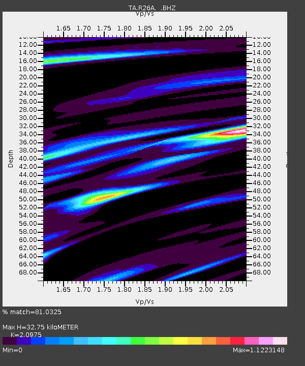
R26A Arlington, CO, USA - Earthquake Result Viewer

Earthquake location: Fox Islands, Aleutian Islands
Earthquake latitude/longitude: 52.8/-167.0
Earthquake time(UTC): 2009/10/13 (286) 05:37:23 GMT
Earthquake Depth: 24 km
Earthquake Magnitude: 6.0 MB, 6.1 MS, 6.5 MW, 6.5 MW
Earthquake Catalog/Contributor: WHDF/NEIC
Network: TA USArray Transportable Network (new EarthScope stations)
Station: R26A Arlington, CO, USA
Lat/Lon: 38.30 N/103.45 W
Elevation: 1304 m
Distance: 45.3 deg
Az: 82.17 deg
Baz: 310.064 deg
Ray Param: 0.0713157
Estimated Moho Depth: 32.75 km
Estimated Crust Vp/Vs: 2.10
Assumed Crust Vp: 6.242 km/s
Estimated Crust Vs: 2.976 km/s
Estimated Crust Poisson's Ratio: 0.35
Radial Match: 81.0325 %
Radial Bump: 400
Transverse Match: 66.769325 %
Transverse Bump: 400
SOD ConfigId: 2622
Insert Time: 2010-03-06 19:59:16.261 +0000
GWidth: 2.5
Max Bumps: 400
Tol: 0.001

Signal To Noise

ChannelStoNSTALTA
TA:R26A: :BHZ:20091013T05:45:08.850004Z2.78370626.109504E-72.1947373E-7
TA:R26A: :BHN:20091013T05:45:08.850004Z2.747064.392657E-71.5990395E-7
TA:R26A: :BHE:20091013T05:45:08.850004Z1.52731293.1863783E-72.0862642E-7
Arrivals
Ps6.1 SECOND
PpPs15 SECOND
PsPs/PpSs22 SECOND