You are here: Home > Network List > TA - USArray Transportable Network (new EarthScope stations) Stations List
> Station R26A Arlington, CO, USA > Earthquake Result Viewer
R26A Arlington, CO, USA - Earthquake Result Viewer
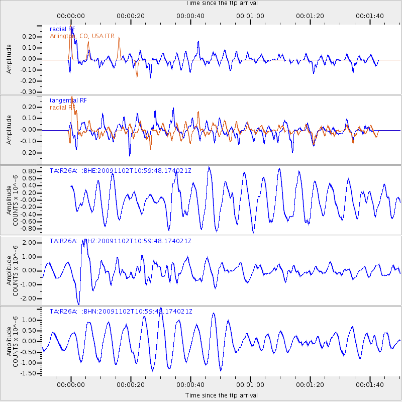
| Earthquake location: |
South Of Tonga Islands |
| Earthquake latitude/longitude: |
-24.1/-175.2 |
| Earthquake time(UTC): |
2009/11/02 (306) 10:47:13 GMT |
| Earthquake Depth: |
9.0 km |
| Earthquake Magnitude: |
6.1 MB, 6.1 MS, 6.2 MW, 6.1 MW |
| Earthquake Catalog/Contributor: |
WHDF/NEIC |
|
| Network: |
TA USArray Transportable Network (new EarthScope stations) |
| Station: |
R26A Arlington, CO, USA |
| Lat/Lon: |
38.30 N/103.45 W |
| Elevation: |
1304 m |
|
| Distance: |
91.5 deg |
| Az: |
48.361 deg |
| Baz: |
240.216 deg |
| Ray Param: |
0.041600905 |
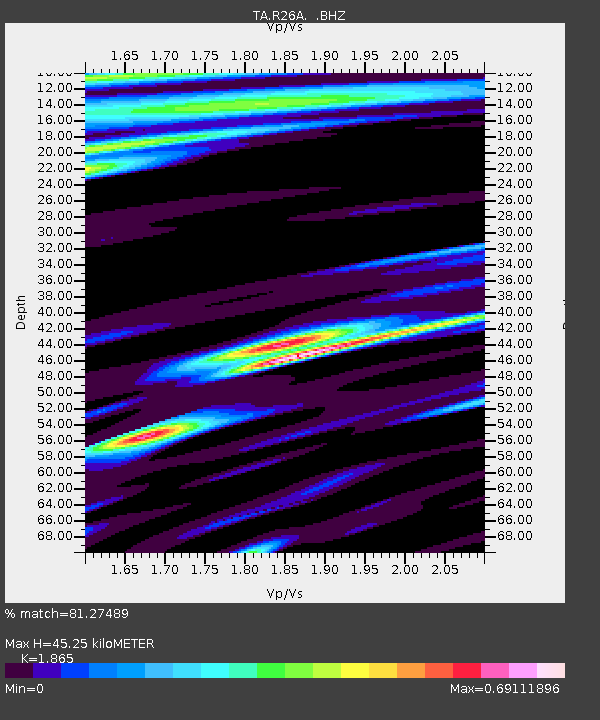
| Estimated Moho Depth: |
45.25 km |
| Estimated Crust Vp/Vs: |
1.87 |
| Assumed Crust Vp: |
6.242 km/s |
| Estimated Crust Vs: |
3.347 km/s |
| Estimated Crust Poisson's Ratio: |
0.30 |
|
| Radial Match: |
81.27489 % |
| Radial Bump: |
400 |
| Transverse Match: |
93.10399 % |
| Transverse Bump: |
338 |
| SOD ConfigId: |
2622 |
| Insert Time: |
2010-03-06 19:59:19.361 +0000 |
| GWidth: |
2.5 |
| Max Bumps: |
400 |
| Tol: |
0.001 |
|
Signal To Noise
| Channel | StoN | STA | LTA |
| TA:R26A: :BHZ:20091102T10:59:48.174021Z | 4.3097177 | 1.4430418E-6 | 3.3483443E-7 |
| TA:R26A: :BHN:20091102T10:59:48.174021Z | 2.418948 | 4.833573E-7 | 1.998213E-7 |
| TA:R26A: :BHE:20091102T10:59:48.174021Z | 1.2467637 | 3.9742466E-7 | 3.1876502E-7 |
| Arrivals |
| Ps | 6.4 SECOND |
| PpPs | 20 SECOND |
| PsPs/PpSs | 27 SECOND |


