You are here: Home > Network List > TA - USArray Transportable Network (new EarthScope stations) Stations List
> Station R26A Arlington, CO, USA > Earthquake Result Viewer
R26A Arlington, CO, USA - Earthquake Result Viewer
| Earthquake location: |
Hokkaido, Japan Region |
| Earthquake latitude/longitude: |
41.8/143.4 |
| Earthquake time(UTC): |
2009/06/05 (156) 03:30:33 GMT |
| Earthquake Depth: |
29 km |
| Earthquake Magnitude: |
6.0 MB, 6.3 MS, 6.4 MW, 6.4 MW |
| Earthquake Catalog/Contributor: |
WHDF/NEIC |
|
| Network: |
TA USArray Transportable Network (new EarthScope stations) |
| Station: |
R26A Arlington, CO, USA |
| Lat/Lon: |
38.30 N/103.45 W |
| Elevation: |
1304 m |
|
| Distance: |
79.7 deg |
| Az: |
47.356 deg |
| Baz: |
315.672 deg |
| Ray Param: |
0.048762728 |
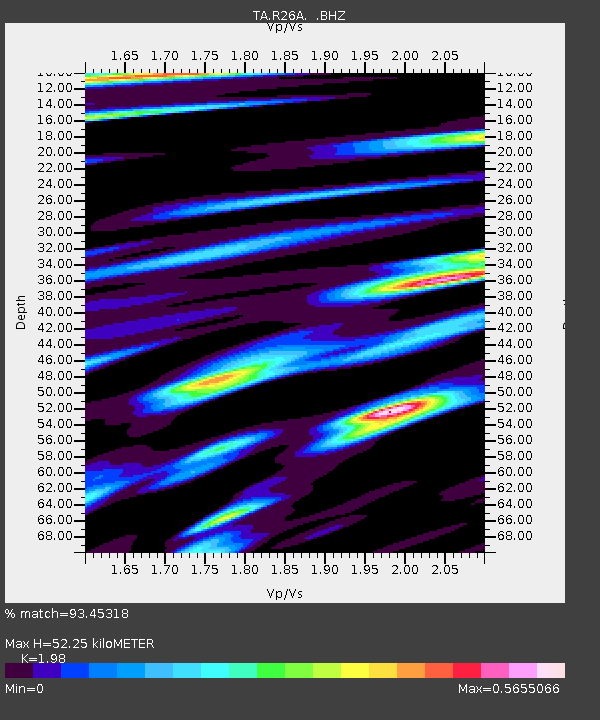
| Estimated Moho Depth: |
52.25 km |
| Estimated Crust Vp/Vs: |
1.98 |
| Assumed Crust Vp: |
6.242 km/s |
| Estimated Crust Vs: |
3.153 km/s |
| Estimated Crust Poisson's Ratio: |
0.33 |
|
| Radial Match: |
93.45318 % |
| Radial Bump: |
343 |
| Transverse Match: |
83.44871 % |
| Transverse Bump: |
400 |
| SOD ConfigId: |
2648 |
| Insert Time: |
2010-03-06 19:59:21.848 +0000 |
| GWidth: |
2.5 |
| Max Bumps: |
400 |
| Tol: |
0.001 |
|
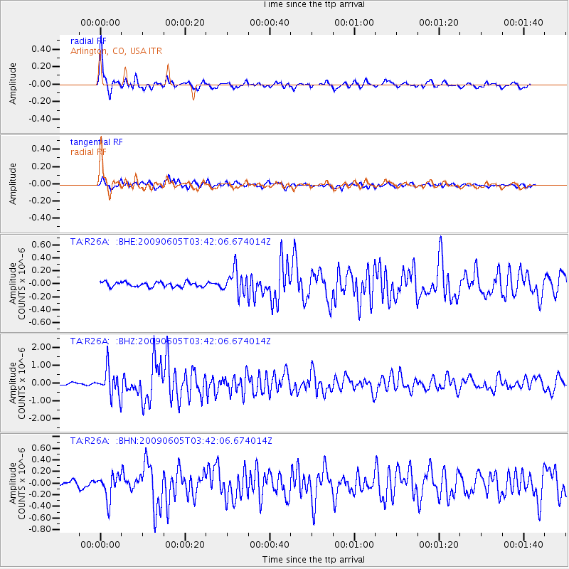
Signal To Noise
| Channel | StoN | STA | LTA |
| TA:R26A: :BHZ:20090605T03:42:06.674014Z | 11.444434 | 7.672366E-7 | 6.7040155E-8 |
| TA:R26A: :BHN:20090605T03:42:06.674014Z | 4.7256293 | 2.135202E-7 | 4.518344E-8 |
| TA:R26A: :BHE:20090605T03:42:06.674014Z | 5.128029 | 1.8471967E-7 | 3.602157E-8 |
| Arrivals |
| Ps | 8.4 SECOND |
| PpPs | 24 SECOND |
| PsPs/PpSs | 33 SECOND |


