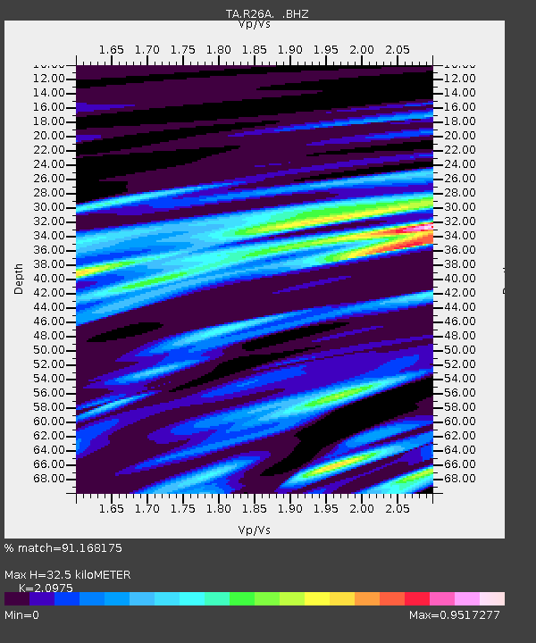
R26A Arlington, CO, USA - Earthquake Result Viewer
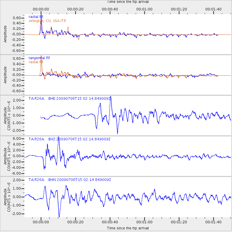
Earthquake location: Rat Islands, Aleutian Islands
Earthquake latitude/longitude: 50.4/177.0
Earthquake time(UTC): 2009/07/06 (187) 14:53:12 GMT
Earthquake Depth: 22 km
Earthquake Magnitude: 6.0 MB, 5.8 MS, 6.1 MW, 6.0 MW
Earthquake Catalog/Contributor: WHDF/NEIC
Network: TA USArray Transportable Network (new EarthScope stations)
Station: R26A Arlington, CO, USA
Lat/Lon: 38.30 N/103.45 W
Elevation: 1304 m
Distance: 55.6 deg
Az: 69.772 deg
Baz: 310.3 deg
Ray Param: 0.0646909
Estimated Moho Depth: 32.5 km
Estimated Crust Vp/Vs: 2.10
Assumed Crust Vp: 6.242 km/s
Estimated Crust Vs: 2.976 km/s
Estimated Crust Poisson's Ratio: 0.35
Radial Match: 91.168175 %
Radial Bump: 400
Transverse Match: 77.318756 %
Transverse Bump: 400
SOD ConfigId: 2648
Insert Time: 2010-03-06 19:59:31.313 +0000
GWidth: 2.5
Max Bumps: 400
Tol: 0.001

Signal To Noise

ChannelStoNSTALTA
TA:R26A: :BHZ:20090706T15:02:14.849009Z9.0766652.160813E-62.3806244E-7
TA:R26A: :BHN:20090706T15:02:14.849009Z3.81921657.2517923E-71.8987643E-7
TA:R26A: :BHE:20090706T15:02:14.849009Z4.5692549.139412E-72.000198E-7
Arrivals
Ps6.0 SECOND
PpPs15 SECOND
PsPs/PpSs21 SECOND