You are here: Home > Network List > TA - USArray Transportable Network (new EarthScope stations) Stations List
> Station R26A Arlington, CO, USA > Earthquake Result Viewer
R26A Arlington, CO, USA - Earthquake Result Viewer
| Earthquake location: |
Baffin Bay |
| Earthquake latitude/longitude: |
75.4/-72.5 |
| Earthquake time(UTC): |
2009/07/07 (188) 19:11:46 GMT |
| Earthquake Depth: |
19 km |
| Earthquake Magnitude: |
5.9 MB, 5.7 MS, 6.1 MW, 6.0 MW |
| Earthquake Catalog/Contributor: |
WHDF/NEIC |
|
| Network: |
TA USArray Transportable Network (new EarthScope stations) |
| Station: |
R26A Arlington, CO, USA |
| Lat/Lon: |
38.30 N/103.45 W |
| Elevation: |
1304 m |
|
| Distance: |
39.8 deg |
| Az: |
219.291 deg |
| Baz: |
11.82 deg |
| Ray Param: |
0.07476374 |
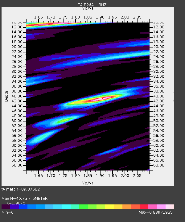
| Estimated Moho Depth: |
40.75 km |
| Estimated Crust Vp/Vs: |
1.91 |
| Assumed Crust Vp: |
6.242 km/s |
| Estimated Crust Vs: |
3.272 km/s |
| Estimated Crust Poisson's Ratio: |
0.31 |
|
| Radial Match: |
89.37682 % |
| Radial Bump: |
332 |
| Transverse Match: |
59.673786 % |
| Transverse Bump: |
400 |
| SOD ConfigId: |
2648 |
| Insert Time: |
2010-03-06 19:59:35.032 +0000 |
| GWidth: |
2.5 |
| Max Bumps: |
400 |
| Tol: |
0.001 |
|
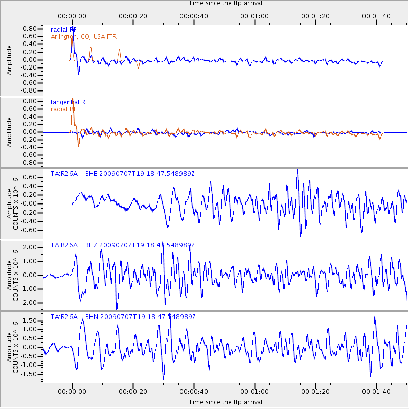
Signal To Noise
| Channel | StoN | STA | LTA |
| TA:R26A: :BHZ:20090707T19:18:47.548989Z | 11.985741 | 1.0522652E-6 | 8.779309E-8 |
| TA:R26A: :BHN:20090707T19:18:47.548989Z | 6.4597173 | 8.8162557E-7 | 1.3648052E-7 |
| TA:R26A: :BHE:20090707T19:18:47.548989Z | 2.7334118 | 2.8800358E-7 | 1.0536414E-7 |
| Arrivals |
| Ps | 6.3 SECOND |
| PpPs | 18 SECOND |
| PsPs/PpSs | 24 SECOND |


