You are here: Home > Network List > TA - USArray Transportable Network (new EarthScope stations) Stations List
> Station R26A Arlington, CO, USA > Earthquake Result Viewer
R26A Arlington, CO, USA - Earthquake Result Viewer
| Earthquake location: |
Southern Peru |
| Earthquake latitude/longitude: |
-15.0/-70.4 |
| Earthquake time(UTC): |
2009/07/12 (193) 06:12:47 GMT |
| Earthquake Depth: |
199 km |
| Earthquake Magnitude: |
5.7 MB, 6.1 MW, 6.1 MW |
| Earthquake Catalog/Contributor: |
WHDF/NEIC |
|
| Network: |
TA USArray Transportable Network (new EarthScope stations) |
| Station: |
R26A Arlington, CO, USA |
| Lat/Lon: |
38.30 N/103.45 W |
| Elevation: |
1304 m |
|
| Distance: |
61.4 deg |
| Az: |
330.792 deg |
| Baz: |
143.184 deg |
| Ray Param: |
0.060267527 |
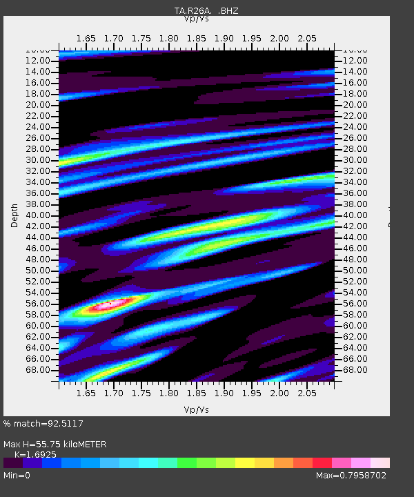
| Estimated Moho Depth: |
55.75 km |
| Estimated Crust Vp/Vs: |
1.69 |
| Assumed Crust Vp: |
6.242 km/s |
| Estimated Crust Vs: |
3.688 km/s |
| Estimated Crust Poisson's Ratio: |
0.23 |
|
| Radial Match: |
92.5117 % |
| Radial Bump: |
400 |
| Transverse Match: |
75.770134 % |
| Transverse Bump: |
400 |
| SOD ConfigId: |
2648 |
| Insert Time: |
2010-03-06 19:59:38.499 +0000 |
| GWidth: |
2.5 |
| Max Bumps: |
400 |
| Tol: |
0.001 |
|
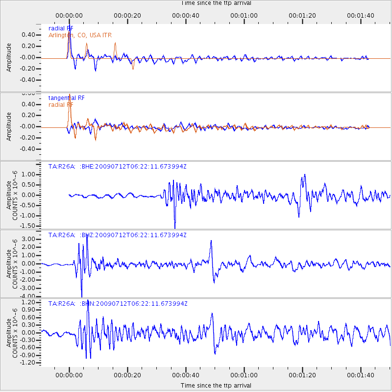
Signal To Noise
| Channel | StoN | STA | LTA |
| TA:R26A: :BHZ:20090712T06:22:11.673994Z | 16.526245 | 1.2010056E-6 | 7.267262E-8 |
| TA:R26A: :BHN:20090712T06:22:11.673994Z | 3.9755833 | 2.7160627E-7 | 6.831859E-8 |
| TA:R26A: :BHE:20090712T06:22:11.673994Z | 4.007276 | 2.5081061E-7 | 6.25888E-8 |
| Arrivals |
| Ps | 6.5 SECOND |
| PpPs | 23 SECOND |
| PsPs/PpSs | 29 SECOND |


