You are here: Home > Network List > TA - USArray Transportable Network (new EarthScope stations) Stations List
> Station R26A Arlington, CO, USA > Earthquake Result Viewer
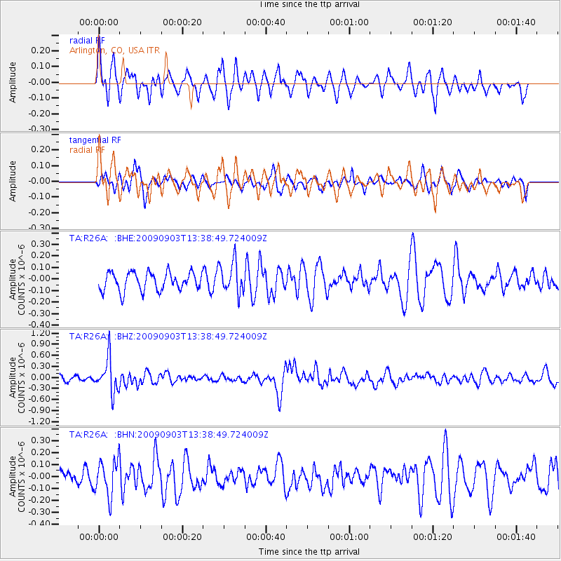
R26A Arlington, CO, USA - Earthquake Result Viewer
*The percent match for this event was below the threshold and hence no stack was calculated.
| Earthquake location: |
Kyushu, Japan |
| Earthquake latitude/longitude: |
31.1/130.0 |
| Earthquake time(UTC): |
2009/09/03 (246) 13:26:18 GMT |
| Earthquake Depth: |
166 km |
| Earthquake Magnitude: |
5.9 MB, 6.2 MW, 6.2 MW |
| Earthquake Catalog/Contributor: |
WHDF/NEIC |
|
| Network: |
TA USArray Transportable Network (new EarthScope stations) |
| Station: |
R26A Arlington, CO, USA |
| Lat/Lon: |
38.30 N/103.45 W |
| Elevation: |
1304 m |
|
| Distance: |
94.8 deg |
| Az: |
39.38 deg |
| Baz: |
316.257 deg |
| Ray Param: |
$rayparam |
*The percent match for this event was below the threshold and hence was not used in the summary stack. |
|
| Radial Match: |
56.204185 % |
| Radial Bump: |
395 |
| Transverse Match: |
51.700386 % |
| Transverse Bump: |
330 |
| SOD ConfigId: |
2622 |
| Insert Time: |
2010-03-06 20:00:01.538 +0000 |
| GWidth: |
2.5 |
| Max Bumps: |
400 |
| Tol: |
0.001 |
|
Signal To Noise
| Channel | StoN | STA | LTA |
| TA:R26A: :BHZ:20090903T13:38:49.724009Z | 6.61475 | 4.7464414E-7 | 7.175542E-8 |
| TA:R26A: :BHN:20090903T13:38:49.724009Z | 1.6253642 | 1.5167757E-7 | 9.331913E-8 |
| TA:R26A: :BHE:20090903T13:38:49.724009Z | 1.6908327 | 1.3355607E-7 | 7.898834E-8 |
| Arrivals |
| Ps | |
| PpPs | |
| PsPs/PpSs | |


