You are here: Home > Network List > TA - USArray Transportable Network (new EarthScope stations) Stations List
> Station R26A Arlington, CO, USA > Earthquake Result Viewer
R26A Arlington, CO, USA - Earthquake Result Viewer
*The percent match for this event was below the threshold and hence no stack was calculated.
| Earthquake location: |
Samoa Islands Region |
| Earthquake latitude/longitude: |
-15.6/-172.0 |
| Earthquake time(UTC): |
2009/09/29 (272) 18:08:21 GMT |
| Earthquake Depth: |
10 km |
| Earthquake Magnitude: |
5.6 MB |
| Earthquake Catalog/Contributor: |
WHDF/NEIC |
|
| Network: |
TA USArray Transportable Network (new EarthScope stations) |
| Station: |
R26A Arlington, CO, USA |
| Lat/Lon: |
38.30 N/103.45 W |
| Elevation: |
1304 m |
|
| Distance: |
83.5 deg |
| Az: |
47.482 deg |
| Baz: |
244.545 deg |
| Ray Param: |
$rayparam |
*The percent match for this event was below the threshold and hence was not used in the summary stack. |
|
| Radial Match: |
68.690475 % |
| Radial Bump: |
355 |
| Transverse Match: |
64.72997 % |
| Transverse Bump: |
292 |
| SOD ConfigId: |
2622 |
| Insert Time: |
2010-03-06 20:00:03.912 +0000 |
| GWidth: |
2.5 |
| Max Bumps: |
400 |
| Tol: |
0.001 |
|
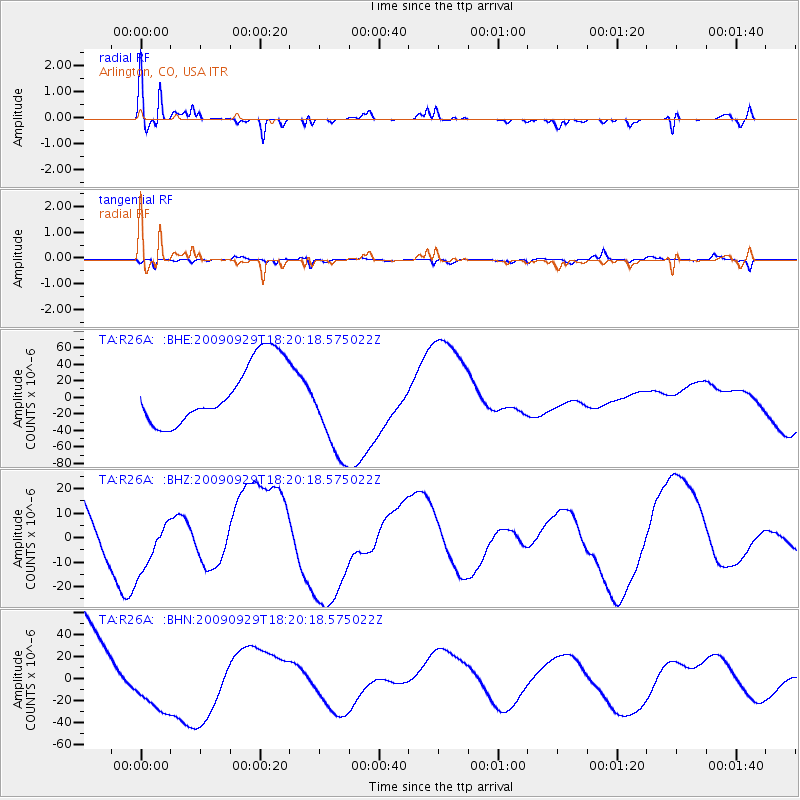
Signal To Noise
| Channel | StoN | STA | LTA |
| TA:R26A: :BHZ:20090929T18:20:18.575022Z | 0.6394704 | 1.0292185E-5 | 1.6094857E-5 |
| TA:R26A: :BHN:20090929T18:20:18.575022Z | 0.7194825 | 2.8651046E-5 | 3.982174E-5 |
| TA:R26A: :BHE:20090929T18:20:18.575022Z | 1.6547638 | 6.131062E-5 | 3.7050973E-5 |
| Arrivals |
| Ps | |
| PpPs | |
| PsPs/PpSs | |


