You are here: Home > Network List > TA - USArray Transportable Network (new EarthScope stations) Stations List
> Station R26A Arlington, CO, USA > Earthquake Result Viewer
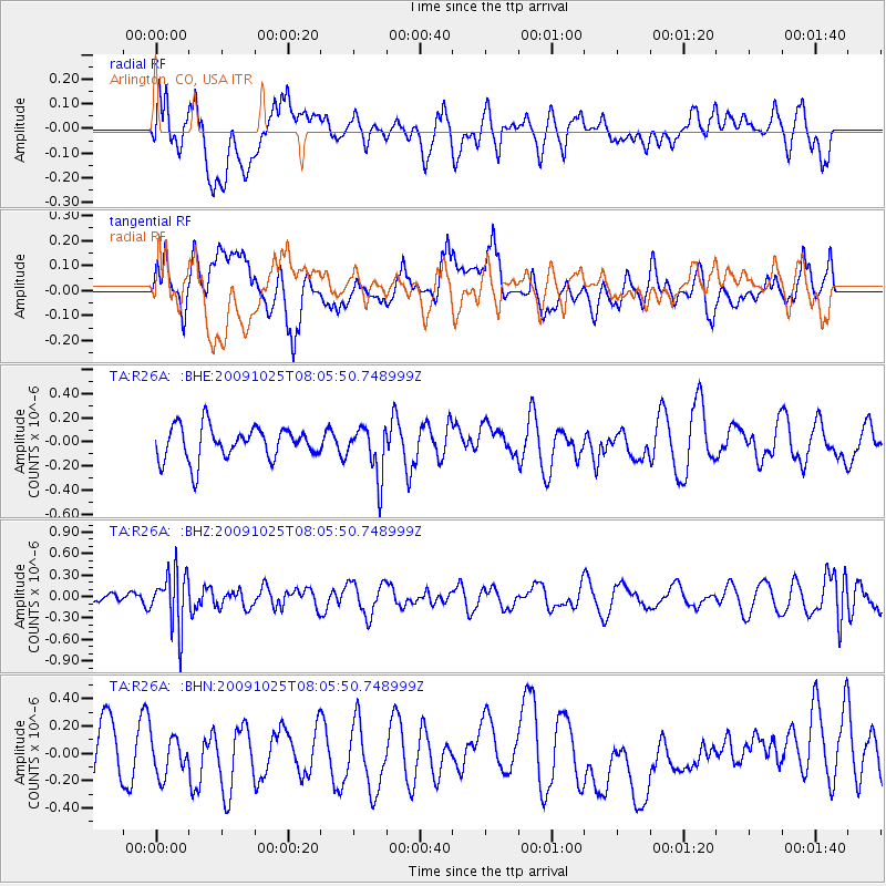
R26A Arlington, CO, USA - Earthquake Result Viewer
*The percent match for this event was below the threshold and hence no stack was calculated.
| Earthquake location: |
South Of Fiji Islands |
| Earthquake latitude/longitude: |
-23.1/-179.2 |
| Earthquake time(UTC): |
2009/10/25 (298) 07:53:52 GMT |
| Earthquake Depth: |
418 km |
| Earthquake Magnitude: |
5.6 MB, 6.0 MW, 5.9 MW |
| Earthquake Catalog/Contributor: |
WHDF/NEIC |
|
| Network: |
TA USArray Transportable Network (new EarthScope stations) |
| Station: |
R26A Arlington, CO, USA |
| Lat/Lon: |
38.30 N/103.45 W |
| Elevation: |
1304 m |
|
| Distance: |
93.6 deg |
| Az: |
49.827 deg |
| Baz: |
243.415 deg |
| Ray Param: |
$rayparam |
*The percent match for this event was below the threshold and hence was not used in the summary stack. |
|
| Radial Match: |
53.195614 % |
| Radial Bump: |
400 |
| Transverse Match: |
34.92421 % |
| Transverse Bump: |
400 |
| SOD ConfigId: |
2622 |
| Insert Time: |
2010-03-06 20:00:15.532 +0000 |
| GWidth: |
2.5 |
| Max Bumps: |
400 |
| Tol: |
0.001 |
|
Signal To Noise
| Channel | StoN | STA | LTA |
| TA:R26A: :BHZ:20091025T08:05:50.748999Z | 2.7161653 | 3.8748803E-7 | 1.4265996E-7 |
| TA:R26A: :BHN:20091025T08:05:50.748999Z | 0.70944405 | 1.3666322E-7 | 1.9263423E-7 |
| TA:R26A: :BHE:20091025T08:05:50.748999Z | 1.5150025 | 2.0674972E-7 | 1.3646823E-7 |
| Arrivals |
| Ps | |
| PpPs | |
| PsPs/PpSs | |


