You are here: Home > Network List > TA - USArray Transportable Network (new EarthScope stations) Stations List
> Station R26A Arlington, CO, USA > Earthquake Result Viewer
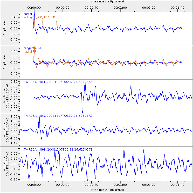
R26A Arlington, CO, USA - Earthquake Result Viewer
*The percent match for this event was below the threshold and hence no stack was calculated.
| Earthquake location: |
Northern Mid-Atlantic Ridge |
| Earthquake latitude/longitude: |
13.4/-44.8 |
| Earthquake time(UTC): |
2008/12/07 (342) 06:23:09 GMT |
| Earthquake Depth: |
10 km |
| Earthquake Magnitude: |
5.6 MB, 5.3 MS, 5.7 MW |
| Earthquake Catalog/Contributor: |
WHDF/NEIC |
|
| Network: |
TA USArray Transportable Network (new EarthScope stations) |
| Station: |
R26A Arlington, CO, USA |
| Lat/Lon: |
38.30 N/103.45 W |
| Elevation: |
1304 m |
|
| Distance: |
57.3 deg |
| Az: |
307.032 deg |
| Baz: |
99.046 deg |
| Ray Param: |
$rayparam |
*The percent match for this event was below the threshold and hence was not used in the summary stack. |
|
| Radial Match: |
71.65264 % |
| Radial Bump: |
355 |
| Transverse Match: |
55.236286 % |
| Transverse Bump: |
362 |
| SOD ConfigId: |
2658 |
| Insert Time: |
2010-03-06 20:00:29.653 +0000 |
| GWidth: |
2.5 |
| Max Bumps: |
400 |
| Tol: |
0.001 |
|
Signal To Noise
| Channel | StoN | STA | LTA |
| TA:R26A: :BHZ:20081207T06:32:26.625027Z | 6.7069926 | 5.764477E-7 | 8.594726E-8 |
| TA:R26A: :BHN:20081207T06:32:26.625027Z | 0.9050687 | 9.696226E-8 | 1.07132486E-7 |
| TA:R26A: :BHE:20081207T06:32:26.625027Z | 4.5399795 | 2.9838125E-7 | 6.572304E-8 |
| Arrivals |
| Ps | |
| PpPs | |
| PsPs/PpSs | |


