You are here: Home > Network List > TA - USArray Transportable Network (new EarthScope stations) Stations List
> Station G31M Satah River, YT, CAN > Earthquake Result Viewer
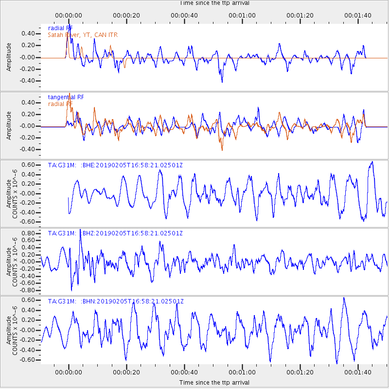
G31M Satah River, YT, CAN - Earthquake Result Viewer
*The percent match for this event was below the threshold and hence no stack was calculated.
| Earthquake location: |
Northwestern Kashmir |
| Earthquake latitude/longitude: |
35.1/74.2 |
| Earthquake time(UTC): |
2019/02/05 (036) 16:47:08 GMT |
| Earthquake Depth: |
33 km |
| Earthquake Magnitude: |
5.3 Mww |
| Earthquake Catalog/Contributor: |
NEIC PDE/us |
|
| Network: |
TA USArray Transportable Network (new EarthScope stations) |
| Station: |
G31M Satah River, YT, CAN |
| Lat/Lon: |
66.92 N/134.27 W |
| Elevation: |
61 m |
|
| Distance: |
76.0 deg |
| Az: |
11.155 deg |
| Baz: |
336.262 deg |
| Ray Param: |
$rayparam |
*The percent match for this event was below the threshold and hence was not used in the summary stack. |
|
| Radial Match: |
69.00946 % |
| Radial Bump: |
396 |
| Transverse Match: |
47.87264 % |
| Transverse Bump: |
389 |
| SOD ConfigId: |
13570011 |
| Insert Time: |
2019-05-02 12:14:09.048 +0000 |
| GWidth: |
2.5 |
| Max Bumps: |
400 |
| Tol: |
0.001 |
|
Signal To Noise
| Channel | StoN | STA | LTA |
| TA:G31M: :BHZ:20190205T16:58:21.02501Z | 2.1928904 | 4.1530654E-7 | 1.8938773E-7 |
| TA:G31M: :BHN:20190205T16:58:21.02501Z | 1.4268465 | 2.2042741E-7 | 1.5448573E-7 |
| TA:G31M: :BHE:20190205T16:58:21.02501Z | 1.7283158 | 3.1959814E-7 | 1.8491883E-7 |
| Arrivals |
| Ps | |
| PpPs | |
| PsPs/PpSs | |


