You are here: Home > Network List > TA - USArray Transportable Network (new EarthScope stations) Stations List
> Station TOLK Toolik Lake Research Station, AK, USA > Earthquake Result Viewer
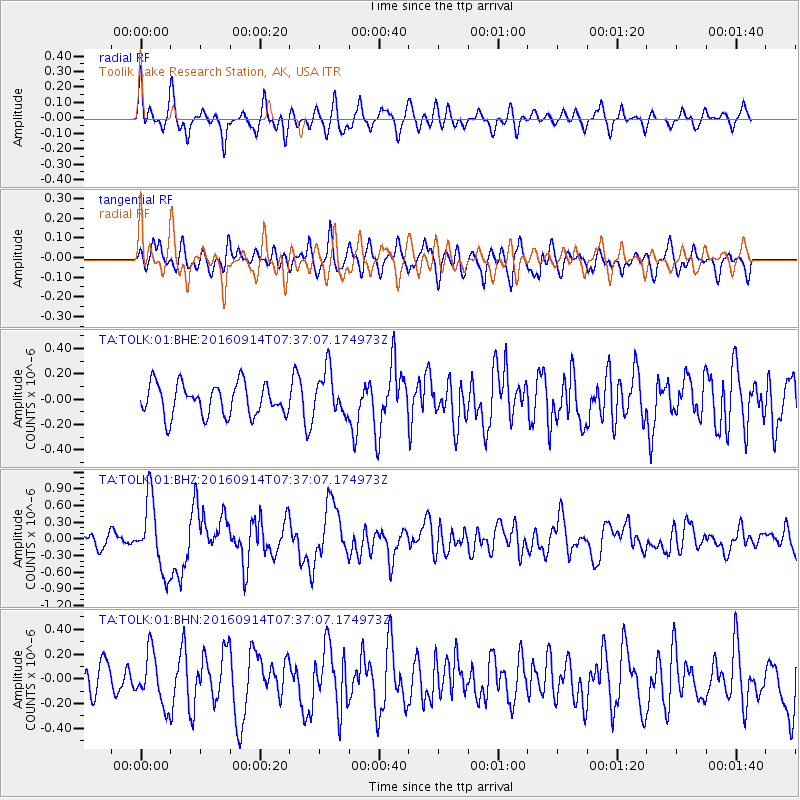
TOLK Toolik Lake Research Station, AK, USA - Earthquake Result Viewer
*The percent match for this event was below the threshold and hence no stack was calculated.
| Earthquake location: |
Solomon Islands |
| Earthquake latitude/longitude: |
-9.4/159.1 |
| Earthquake time(UTC): |
2016/09/14 (258) 07:24:59 GMT |
| Earthquake Depth: |
10 km |
| Earthquake Magnitude: |
6.0 MWB |
| Earthquake Catalog/Contributor: |
NEIC PDE/NEIC COMCAT |
|
| Network: |
TA USArray Transportable Network (new EarthScope stations) |
| Station: |
TOLK Toolik Lake Research Station, AK, USA |
| Lat/Lon: |
68.64 N/149.57 W |
| Elevation: |
760 m |
|
| Distance: |
85.7 deg |
| Az: |
16.658 deg |
| Baz: |
230.55 deg |
| Ray Param: |
$rayparam |
*The percent match for this event was below the threshold and hence was not used in the summary stack. |
|
| Radial Match: |
74.6872 % |
| Radial Bump: |
400 |
| Transverse Match: |
50.246967 % |
| Transverse Bump: |
400 |
| SOD ConfigId: |
1634031 |
| Insert Time: |
2016-09-28 07:27:53.729 +0000 |
| GWidth: |
2.5 |
| Max Bumps: |
400 |
| Tol: |
0.001 |
|
Signal To Noise
| Channel | StoN | STA | LTA |
| TA:TOLK:01:BHZ:20160914T07:37:07.174973Z | 5.1216226 | 6.3263275E-7 | 1.2352193E-7 |
| TA:TOLK:01:BHN:20160914T07:37:07.174973Z | 1.6479923 | 2.0957364E-7 | 1.2716907E-7 |
| TA:TOLK:01:BHE:20160914T07:37:07.174973Z | 1.4196148 | 1.7621097E-7 | 1.241259E-7 |
| Arrivals |
| Ps | |
| PpPs | |
| PsPs/PpSs | |


