You are here: Home > Network List > TA - USArray Transportable Network (new EarthScope stations) Stations List
> Station S26A Kim, CO, USA > Earthquake Result Viewer
S26A Kim, CO, USA - Earthquake Result Viewer
| Earthquake location: |
Costa Rica |
| Earthquake latitude/longitude: |
10.2/-84.2 |
| Earthquake time(UTC): |
2009/01/08 (008) 19:21:35 GMT |
| Earthquake Depth: |
14 km |
| Earthquake Magnitude: |
5.7 MB, 6.0 MS, 6.1 MW, 6.1 MW |
| Earthquake Catalog/Contributor: |
WHDF/NEIC |
|
| Network: |
TA USArray Transportable Network (new EarthScope stations) |
| Station: |
S26A Kim, CO, USA |
| Lat/Lon: |
37.62 N/103.47 W |
| Elevation: |
1394 m |
|
| Distance: |
32.4 deg |
| Az: |
330.699 deg |
| Baz: |
142.641 deg |
| Ray Param: |
0.078667946 |
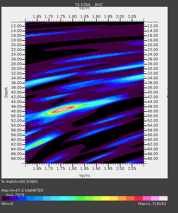
| Estimated Moho Depth: |
47.0 km |
| Estimated Crust Vp/Vs: |
1.76 |
| Assumed Crust Vp: |
6.306 km/s |
| Estimated Crust Vs: |
3.588 km/s |
| Estimated Crust Poisson's Ratio: |
0.26 |
|
| Radial Match: |
80.53691 % |
| Radial Bump: |
269 |
| Transverse Match: |
70.27249 % |
| Transverse Bump: |
397 |
| SOD ConfigId: |
2834 |
| Insert Time: |
2010-03-06 20:02:35.775 +0000 |
| GWidth: |
2.5 |
| Max Bumps: |
400 |
| Tol: |
0.001 |
|
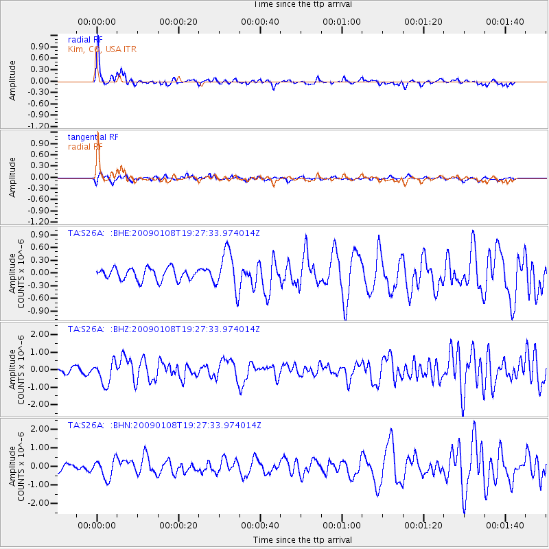
Signal To Noise
| Channel | StoN | STA | LTA |
| TA:S26A: :BHZ:20090108T19:27:33.974014Z | 5.937568 | 6.5245285E-7 | 1.09885534E-7 |
| TA:S26A: :BHN:20090108T19:27:33.974014Z | 2.5846522 | 5.267582E-7 | 2.0380234E-7 |
| TA:S26A: :BHE:20090108T19:27:33.974014Z | 3.4477413 | 4.808141E-7 | 1.3945771E-7 |
| Arrivals |
| Ps | 6.1 SECOND |
| PpPs | 19 SECOND |
| PsPs/PpSs | 25 SECOND |


