You are here: Home > Network List > TA - USArray Transportable Network (new EarthScope stations) Stations List
> Station S26A Kim, CO, USA > Earthquake Result Viewer
S26A Kim, CO, USA - Earthquake Result Viewer
| Earthquake location: |
Santa Cruz Islands |
| Earthquake latitude/longitude: |
-11.6/166.1 |
| Earthquake time(UTC): |
2009/08/10 (222) 04:06:31 GMT |
| Earthquake Depth: |
35 km |
| Earthquake Magnitude: |
5.8 MB, 6.3 MS, 6.6 MW, 6.6 MW |
| Earthquake Catalog/Contributor: |
WHDF/NEIC |
|
| Network: |
TA USArray Transportable Network (new EarthScope stations) |
| Station: |
S26A Kim, CO, USA |
| Lat/Lon: |
37.62 N/103.47 W |
| Elevation: |
1394 m |
|
| Distance: |
97.3 deg |
| Az: |
53.183 deg |
| Baz: |
261.054 deg |
| Ray Param: |
0.040230136 |
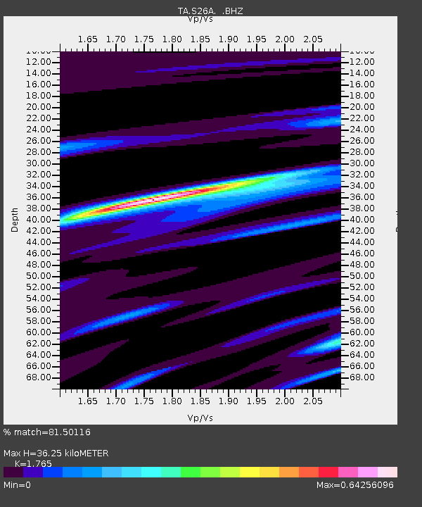
| Estimated Moho Depth: |
36.25 km |
| Estimated Crust Vp/Vs: |
1.76 |
| Assumed Crust Vp: |
6.306 km/s |
| Estimated Crust Vs: |
3.573 km/s |
| Estimated Crust Poisson's Ratio: |
0.26 |
|
| Radial Match: |
81.50116 % |
| Radial Bump: |
400 |
| Transverse Match: |
49.87214 % |
| Transverse Bump: |
400 |
| SOD ConfigId: |
2622 |
| Insert Time: |
2010-03-06 20:02:42.594 +0000 |
| GWidth: |
2.5 |
| Max Bumps: |
400 |
| Tol: |
0.001 |
|
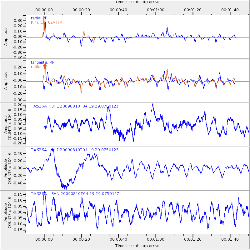
Signal To Noise
| Channel | StoN | STA | LTA |
| TA:S26A: :BHZ:20090810T04:19:29.075012Z | 5.813389 | 3.2890745E-7 | 5.6577576E-8 |
| TA:S26A: :BHN:20090810T04:19:29.075012Z | 1.5751767 | 8.8632525E-8 | 5.6268302E-8 |
| TA:S26A: :BHE:20090810T04:19:29.075012Z | 2.3389292 | 8.280112E-8 | 3.5401293E-8 |
| Arrivals |
| Ps | 4.5 SECOND |
| PpPs | 16 SECOND |
| PsPs/PpSs | 20 SECOND |


