You are here: Home > Network List > TA - USArray Transportable Network (new EarthScope stations) Stations List
> Station S26A Kim, CO, USA > Earthquake Result Viewer
S26A Kim, CO, USA - Earthquake Result Viewer
| Earthquake location: |
Near Coast Of Venezuela |
| Earthquake latitude/longitude: |
10.7/-67.9 |
| Earthquake time(UTC): |
2009/09/12 (255) 20:06:24 GMT |
| Earthquake Depth: |
10 km |
| Earthquake Magnitude: |
6.3 MB, 6.4 MS, 6.3 MW, 6.3 MW |
| Earthquake Catalog/Contributor: |
WHDF/NEIC |
|
| Network: |
TA USArray Transportable Network (new EarthScope stations) |
| Station: |
S26A Kim, CO, USA |
| Lat/Lon: |
37.62 N/103.47 W |
| Elevation: |
1394 m |
|
| Distance: |
41.7 deg |
| Az: |
316.007 deg |
| Baz: |
120.717 deg |
| Ray Param: |
0.07365282 |
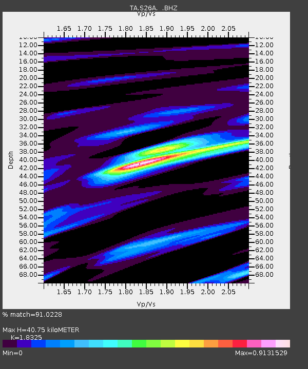
| Estimated Moho Depth: |
40.75 km |
| Estimated Crust Vp/Vs: |
1.83 |
| Assumed Crust Vp: |
6.306 km/s |
| Estimated Crust Vs: |
3.441 km/s |
| Estimated Crust Poisson's Ratio: |
0.29 |
|
| Radial Match: |
91.0228 % |
| Radial Bump: |
208 |
| Transverse Match: |
59.62426 % |
| Transverse Bump: |
276 |
| SOD ConfigId: |
2622 |
| Insert Time: |
2010-03-06 20:02:54.220 +0000 |
| GWidth: |
2.5 |
| Max Bumps: |
400 |
| Tol: |
0.001 |
|
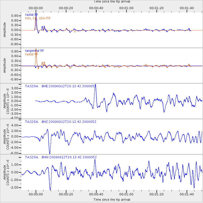
Signal To Noise
| Channel | StoN | STA | LTA |
| TA:S26A: :BHZ:20090912T20:13:42.300005Z | 6.6217613 | 6.4577006E-7 | 9.7522395E-8 |
| TA:S26A: :BHN:20090912T20:13:42.300005Z | 1.7419665 | 2.18422E-7 | 1.2538817E-7 |
| TA:S26A: :BHE:20090912T20:13:42.300005Z | 2.4377606 | 3.4399298E-7 | 1.4111023E-7 |
| Arrivals |
| Ps | 5.7 SECOND |
| PpPs | 17 SECOND |
| PsPs/PpSs | 23 SECOND |


