You are here: Home > Network List > TA - USArray Transportable Network (new EarthScope stations) Stations List
> Station S26A Kim, CO, USA > Earthquake Result Viewer
S26A Kim, CO, USA - Earthquake Result Viewer
| Earthquake location: |
Tonga Islands Region |
| Earthquake latitude/longitude: |
-23.0/-174.7 |
| Earthquake time(UTC): |
2009/03/19 (078) 18:17:40 GMT |
| Earthquake Depth: |
34 km |
| Earthquake Magnitude: |
7.0 MB, 7.6 MS, 7.6 MW, 7.6 MW |
| Earthquake Catalog/Contributor: |
WHDF/NEIC |
|
| Network: |
TA USArray Transportable Network (new EarthScope stations) |
| Station: |
S26A Kim, CO, USA |
| Lat/Lon: |
37.62 N/103.47 W |
| Elevation: |
1394 m |
|
| Distance: |
90.0 deg |
| Az: |
48.731 deg |
| Baz: |
240.683 deg |
| Ray Param: |
0.041697364 |
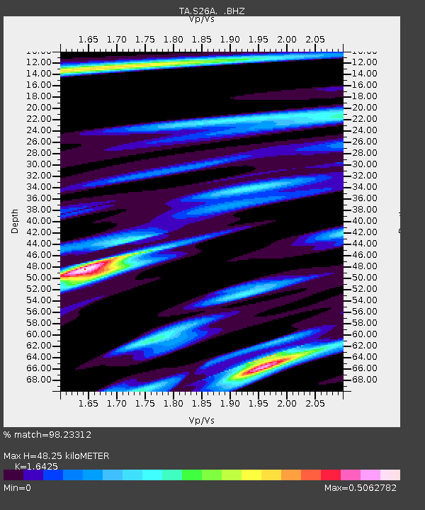
| Estimated Moho Depth: |
48.25 km |
| Estimated Crust Vp/Vs: |
1.64 |
| Assumed Crust Vp: |
6.306 km/s |
| Estimated Crust Vs: |
3.839 km/s |
| Estimated Crust Poisson's Ratio: |
0.21 |
|
| Radial Match: |
98.23312 % |
| Radial Bump: |
400 |
| Transverse Match: |
89.784294 % |
| Transverse Bump: |
400 |
| SOD ConfigId: |
2658 |
| Insert Time: |
2010-03-06 20:03:14.334 +0000 |
| GWidth: |
2.5 |
| Max Bumps: |
400 |
| Tol: |
0.001 |
|
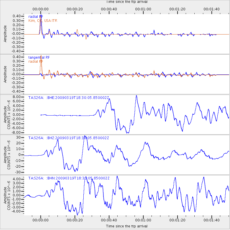
Signal To Noise
| Channel | StoN | STA | LTA |
| TA:S26A: :BHZ:20090319T18:30:05.850002Z | 16.454525 | 3.844875E-6 | 2.3366674E-7 |
| TA:S26A: :BHN:20090319T18:30:05.850002Z | 4.2466908 | 5.402206E-7 | 1.2720977E-7 |
| TA:S26A: :BHE:20090319T18:30:05.850002Z | 9.540214 | 1.1089622E-6 | 1.1624082E-7 |
| Arrivals |
| Ps | 5.0 SECOND |
| PpPs | 20 SECOND |
| PsPs/PpSs | 25 SECOND |


