You are here: Home > Network List > TA - USArray Transportable Network (new EarthScope stations) Stations List
> Station A21K Barrow, AK, USA > Earthquake Result Viewer
A21K Barrow, AK, USA - Earthquake Result Viewer
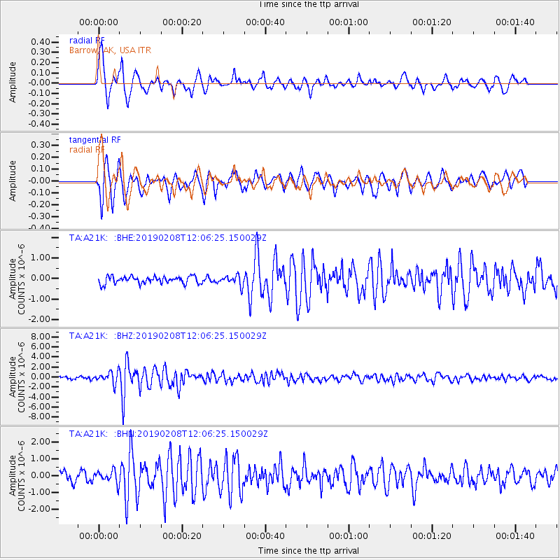
| Earthquake location: |
Mindanao, Philippines |
| Earthquake latitude/longitude: |
9.8/126.5 |
| Earthquake time(UTC): |
2019/02/08 (039) 11:55:08 GMT |
| Earthquake Depth: |
25 km |
| Earthquake Magnitude: |
5.9 Mww |
| Earthquake Catalog/Contributor: |
NEIC PDE/us |
|
| Network: |
TA USArray Transportable Network (new EarthScope stations) |
| Station: |
A21K Barrow, AK, USA |
| Lat/Lon: |
71.32 N/156.62 W |
| Elevation: |
577 m |
|
| Distance: |
76.5 deg |
| Az: |
18.82 deg |
| Baz: |
260.677 deg |
| Ray Param: |
0.05089859 |
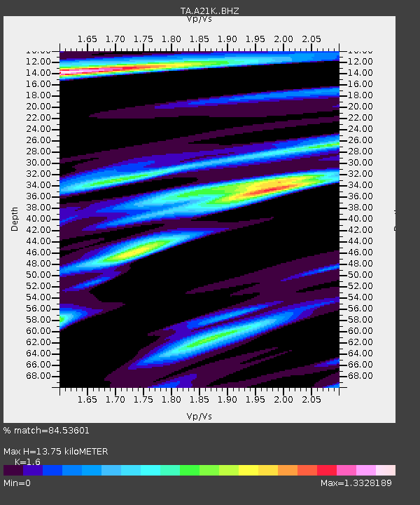
| Estimated Moho Depth: |
13.75 km |
| Estimated Crust Vp/Vs: |
1.60 |
| Assumed Crust Vp: |
6.048 km/s |
| Estimated Crust Vs: |
3.78 km/s |
| Estimated Crust Poisson's Ratio: |
0.18 |
|
| Radial Match: |
84.53601 % |
| Radial Bump: |
390 |
| Transverse Match: |
78.54311 % |
| Transverse Bump: |
391 |
| SOD ConfigId: |
13570011 |
| Insert Time: |
2019-05-02 12:37:53.974 +0000 |
| GWidth: |
2.5 |
| Max Bumps: |
400 |
| Tol: |
0.001 |
|
Signal To Noise
| Channel | StoN | STA | LTA |
| TA:A21K: :BHZ:20190208T12:06:25.150029Z | 5.349741 | 1.1581615E-6 | 2.1648927E-7 |
| TA:A21K: :BHN:20190208T12:06:25.150029Z | 1.1372212 | 3.7599628E-7 | 3.3062722E-7 |
| TA:A21K: :BHE:20190208T12:06:25.150029Z | 1.3979323 | 2.4438873E-7 | 1.7482158E-7 |
| Arrivals |
| Ps | 1.4 SECOND |
| PpPs | 5.7 SECOND |
| PsPs/PpSs | 7.1 SECOND |


