You are here: Home > Network List > TA - USArray Transportable Network (new EarthScope stations) Stations List
> Station D27M Malcolm River, YT, CAN > Earthquake Result Viewer
D27M Malcolm River, YT, CAN - Earthquake Result Viewer
| Earthquake location: |
Mindanao, Philippines |
| Earthquake latitude/longitude: |
9.8/126.5 |
| Earthquake time(UTC): |
2019/02/08 (039) 11:55:08 GMT |
| Earthquake Depth: |
25 km |
| Earthquake Magnitude: |
5.9 Mww |
| Earthquake Catalog/Contributor: |
NEIC PDE/us |
|
| Network: |
TA USArray Transportable Network (new EarthScope stations) |
| Station: |
D27M Malcolm River, YT, CAN |
| Lat/Lon: |
69.24 N/140.96 W |
| Elevation: |
896 m |
|
| Distance: |
81.8 deg |
| Az: |
21.091 deg |
| Baz: |
275.841 deg |
| Ray Param: |
0.047324825 |
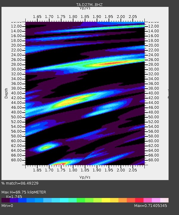
| Estimated Moho Depth: |
69.75 km |
| Estimated Crust Vp/Vs: |
1.75 |
| Assumed Crust Vp: |
6.522 km/s |
| Estimated Crust Vs: |
3.737 km/s |
| Estimated Crust Poisson's Ratio: |
0.26 |
|
| Radial Match: |
86.49229 % |
| Radial Bump: |
400 |
| Transverse Match: |
75.23469 % |
| Transverse Bump: |
400 |
| SOD ConfigId: |
13570011 |
| Insert Time: |
2019-05-02 12:38:20.274 +0000 |
| GWidth: |
2.5 |
| Max Bumps: |
400 |
| Tol: |
0.001 |
|

Signal To Noise
| Channel | StoN | STA | LTA |
| TA:D27M: :BHZ:20190208T12:06:53.650029Z | 5.843552 | 5.1510375E-7 | 8.8149086E-8 |
| TA:D27M: :BHN:20190208T12:06:53.650029Z | 1.3311479 | 1.3842775E-7 | 1.0399126E-7 |
| TA:D27M: :BHE:20190208T12:06:53.650029Z | 2.4186037 | 1.6590941E-7 | 6.8597195E-8 |
| Arrivals |
| Ps | 8.2 SECOND |
| PpPs | 29 SECOND |
| PsPs/PpSs | 37 SECOND |


