You are here: Home > Network List > TA - USArray Transportable Network (new EarthScope stations) Stations List
> Station S26A Kim, CO, USA > Earthquake Result Viewer
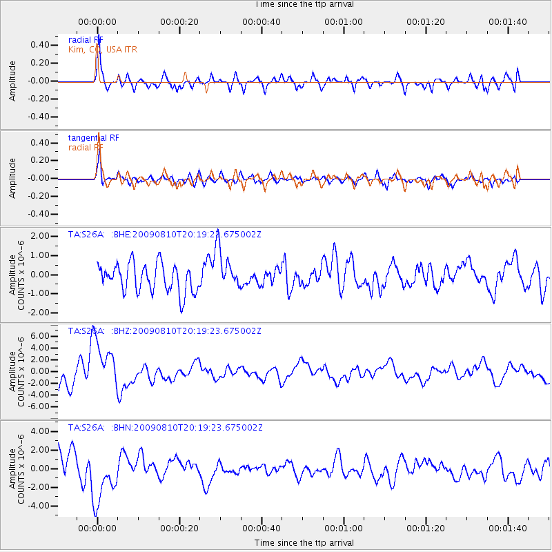
S26A Kim, CO, USA - Earthquake Result Viewer
*The percent match for this event was below the threshold and hence no stack was calculated.
| Earthquake location: |
Near S. Coast Of Honshu, Japan |
| Earthquake latitude/longitude: |
34.7/138.3 |
| Earthquake time(UTC): |
2009/08/10 (222) 20:07:09 GMT |
| Earthquake Depth: |
40 km |
| Earthquake Magnitude: |
6.1 MB |
| Earthquake Catalog/Contributor: |
WHDF/NEIC |
|
| Network: |
TA USArray Transportable Network (new EarthScope stations) |
| Station: |
S26A Kim, CO, USA |
| Lat/Lon: |
37.62 N/103.47 W |
| Elevation: |
1394 m |
|
| Distance: |
88.0 deg |
| Az: |
44.411 deg |
| Baz: |
313.468 deg |
| Ray Param: |
$rayparam |
*The percent match for this event was below the threshold and hence was not used in the summary stack. |
|
| Radial Match: |
74.662605 % |
| Radial Bump: |
400 |
| Transverse Match: |
71.07007 % |
| Transverse Bump: |
400 |
| SOD ConfigId: |
2622 |
| Insert Time: |
2010-03-06 20:03:34.402 +0000 |
| GWidth: |
2.5 |
| Max Bumps: |
400 |
| Tol: |
0.001 |
|
Signal To Noise
| Channel | StoN | STA | LTA |
| TA:S26A: :BHZ:20090810T20:19:23.675002Z | 2.6186633 | 4.2489696E-6 | 1.6225719E-6 |
| TA:S26A: :BHN:20090810T20:19:23.675002Z | 2.611567 | 2.942247E-6 | 1.1266212E-6 |
| TA:S26A: :BHE:20090810T20:19:23.675002Z | 1.4775258 | 1.0810198E-6 | 7.3164193E-7 |
| Arrivals |
| Ps | |
| PpPs | |
| PsPs/PpSs | |


