You are here: Home > Network List > TA - USArray Transportable Network (new EarthScope stations) Stations List
> Station H18K Honhosa River, AK, USA > Earthquake Result Viewer
H18K Honhosa River, AK, USA - Earthquake Result Viewer
| Earthquake location: |
Mindanao, Philippines |
| Earthquake latitude/longitude: |
9.8/126.5 |
| Earthquake time(UTC): |
2019/02/08 (039) 11:55:08 GMT |
| Earthquake Depth: |
25 km |
| Earthquake Magnitude: |
5.9 Mww |
| Earthquake Catalog/Contributor: |
NEIC PDE/us |
|
| Network: |
TA USArray Transportable Network (new EarthScope stations) |
| Station: |
H18K Honhosa River, AK, USA |
| Lat/Lon: |
65.15 N/158.36 W |
| Elevation: |
494 m |
|
| Distance: |
74.9 deg |
| Az: |
25.022 deg |
| Baz: |
260.587 deg |
| Ray Param: |
0.052003972 |
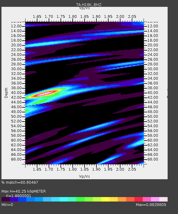
| Estimated Moho Depth: |
40.25 km |
| Estimated Crust Vp/Vs: |
1.68 |
| Assumed Crust Vp: |
6.1 km/s |
| Estimated Crust Vs: |
3.631 km/s |
| Estimated Crust Poisson's Ratio: |
0.23 |
|
| Radial Match: |
80.90467 % |
| Radial Bump: |
323 |
| Transverse Match: |
71.046906 % |
| Transverse Bump: |
358 |
| SOD ConfigId: |
13570011 |
| Insert Time: |
2019-05-02 12:38:49.515 +0000 |
| GWidth: |
2.5 |
| Max Bumps: |
400 |
| Tol: |
0.001 |
|

Signal To Noise
| Channel | StoN | STA | LTA |
| TA:H18K: :BHZ:20190208T12:06:15.700017Z | 4.412359 | 6.2549816E-7 | 1.4176048E-7 |
| TA:H18K: :BHN:20190208T12:06:15.700017Z | 1.1958904 | 1.9290815E-7 | 1.6130923E-7 |
| TA:H18K: :BHE:20190208T12:06:15.700017Z | 1.969679 | 2.910275E-7 | 1.4775377E-7 |
| Arrivals |
| Ps | 4.6 SECOND |
| PpPs | 17 SECOND |
| PsPs/PpSs | 22 SECOND |


