You are here: Home > Network List > TA - USArray Transportable Network (new EarthScope stations) Stations List
> Station I17K Unalakleet, AK, USA > Earthquake Result Viewer
I17K Unalakleet, AK, USA - Earthquake Result Viewer
| Earthquake location: |
Mindanao, Philippines |
| Earthquake latitude/longitude: |
9.8/126.5 |
| Earthquake time(UTC): |
2019/02/08 (039) 11:55:08 GMT |
| Earthquake Depth: |
25 km |
| Earthquake Magnitude: |
5.9 Mww |
| Earthquake Catalog/Contributor: |
NEIC PDE/us |
|
| Network: |
TA USArray Transportable Network (new EarthScope stations) |
| Station: |
I17K Unalakleet, AK, USA |
| Lat/Lon: |
63.89 N/160.70 W |
| Elevation: |
105 m |
|
| Distance: |
73.7 deg |
| Az: |
26.134 deg |
| Baz: |
258.786 deg |
| Ray Param: |
0.05282362 |
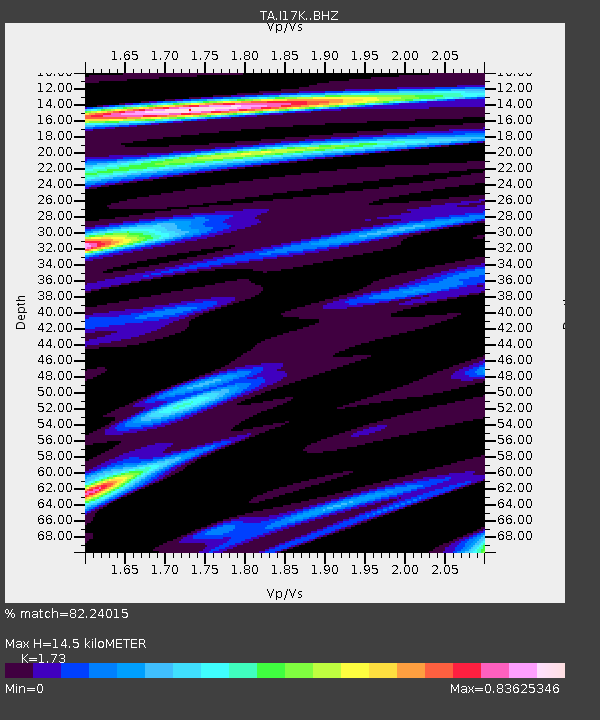
| Estimated Moho Depth: |
14.5 km |
| Estimated Crust Vp/Vs: |
1.73 |
| Assumed Crust Vp: |
6.276 km/s |
| Estimated Crust Vs: |
3.628 km/s |
| Estimated Crust Poisson's Ratio: |
0.25 |
|
| Radial Match: |
82.24015 % |
| Radial Bump: |
388 |
| Transverse Match: |
64.27735 % |
| Transverse Bump: |
400 |
| SOD ConfigId: |
13570011 |
| Insert Time: |
2019-05-02 12:38:56.247 +0000 |
| GWidth: |
2.5 |
| Max Bumps: |
400 |
| Tol: |
0.001 |
|

Signal To Noise
| Channel | StoN | STA | LTA |
| TA:I17K: :BHZ:20190208T12:06:08.625005Z | 3.9363613 | 7.0585463E-7 | 1.7931653E-7 |
| TA:I17K: :BHN:20190208T12:06:08.625005Z | 0.653718 | 1.8730849E-7 | 2.8652795E-7 |
| TA:I17K: :BHE:20190208T12:06:08.625005Z | 2.035405 | 4.4695798E-7 | 2.1959167E-7 |
| Arrivals |
| Ps | 1.7 SECOND |
| PpPs | 6.1 SECOND |
| PsPs/PpSs | 7.8 SECOND |


