You are here: Home > Network List > TA - USArray Transportable Network (new EarthScope stations) Stations List
> Station J20K Nowitna River, AK, USA > Earthquake Result Viewer
J20K Nowitna River, AK, USA - Earthquake Result Viewer

| Earthquake location: |
Mindanao, Philippines |
| Earthquake latitude/longitude: |
9.8/126.5 |
| Earthquake time(UTC): |
2019/02/08 (039) 11:55:08 GMT |
| Earthquake Depth: |
25 km |
| Earthquake Magnitude: |
5.9 Mww |
| Earthquake Catalog/Contributor: |
NEIC PDE/us |
|
| Network: |
TA USArray Transportable Network (new EarthScope stations) |
| Station: |
J20K Nowitna River, AK, USA |
| Lat/Lon: |
64.18 N/154.15 W |
| Elevation: |
314 m |
|
| Distance: |
76.6 deg |
| Az: |
26.264 deg |
| Baz: |
264.7 deg |
| Ray Param: |
0.050884917 |
| Estimated Moho Depth: |
27.5 km |
| Estimated Crust Vp/Vs: |
2.05 |
| Assumed Crust Vp: |
6.566 km/s |
| Estimated Crust Vs: |
3.211 km/s |
| Estimated Crust Poisson's Ratio: |
0.34 |
|
| Radial Match: |
87.58429 % |
| Radial Bump: |
324 |
| Transverse Match: |
71.884895 % |
| Transverse Bump: |
400 |
| SOD ConfigId: |
13570011 |
| Insert Time: |
2019-05-02 12:39:06.921 +0000 |
| GWidth: |
2.5 |
| Max Bumps: |
400 |
| Tol: |
0.001 |
|
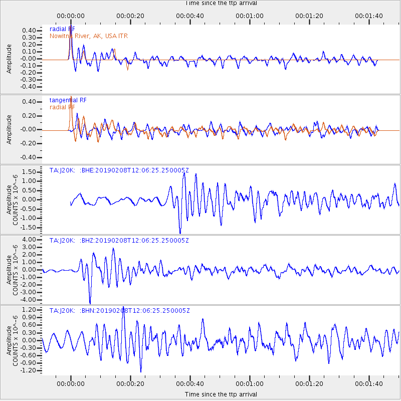
Signal To Noise
| Channel | StoN | STA | LTA |
| TA:J20K: :BHZ:20190208T12:06:25.250005Z | 2.7481756 | 6.42077E-7 | 2.3363755E-7 |
| TA:J20K: :BHN:20190208T12:06:25.250005Z | 0.66825235 | 2.4824593E-7 | 3.714853E-7 |
| TA:J20K: :BHE:20190208T12:06:25.250005Z | 2.134596 | 3.4276437E-7 | 1.6057574E-7 |
| Arrivals |
| Ps | 4.5 SECOND |
| PpPs | 12 SECOND |
| PsPs/PpSs | 17 SECOND |


