You are here: Home > Network List > TA - USArray Transportable Network (new EarthScope stations) Stations List
> Station S26A Kim, CO, USA > Earthquake Result Viewer
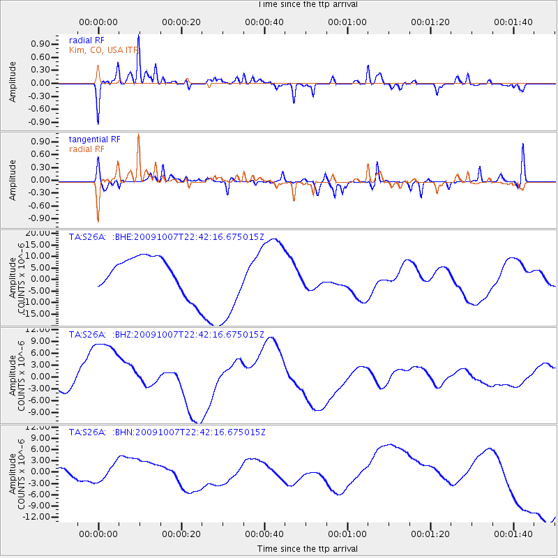
S26A Kim, CO, USA - Earthquake Result Viewer
*The percent match for this event was below the threshold and hence no stack was calculated.
| Earthquake location: |
Santa Cruz Islands |
| Earthquake latitude/longitude: |
-11.5/166.0 |
| Earthquake time(UTC): |
2009/10/07 (280) 22:29:18 GMT |
| Earthquake Depth: |
35 km |
| Earthquake Magnitude: |
5.5 MB |
| Earthquake Catalog/Contributor: |
WHDF/NEIC |
|
| Network: |
TA USArray Transportable Network (new EarthScope stations) |
| Station: |
S26A Kim, CO, USA |
| Lat/Lon: |
37.62 N/103.47 W |
| Elevation: |
1394 m |
|
| Distance: |
97.3 deg |
| Az: |
53.179 deg |
| Baz: |
261.174 deg |
| Ray Param: |
$rayparam |
*The percent match for this event was below the threshold and hence was not used in the summary stack. |
|
| Radial Match: |
76.952446 % |
| Radial Bump: |
312 |
| Transverse Match: |
70.902176 % |
| Transverse Bump: |
354 |
| SOD ConfigId: |
2622 |
| Insert Time: |
2010-03-06 20:03:54.419 +0000 |
| GWidth: |
2.5 |
| Max Bumps: |
400 |
| Tol: |
0.001 |
|
Signal To Noise
| Channel | StoN | STA | LTA |
| TA:S26A: :BHZ:20091007T22:42:16.675015Z | 3.3245108 | 1.0331465E-5 | 3.1076647E-6 |
| TA:S26A: :BHN:20091007T22:42:16.675015Z | 0.5088982 | 2.467061E-6 | 4.847848E-6 |
| TA:S26A: :BHE:20091007T22:42:16.675015Z | 2.1664755 | 1.6857597E-5 | 7.7811155E-6 |
| Arrivals |
| Ps | |
| PpPs | |
| PsPs/PpSs | |


