You are here: Home > Network List > TA - USArray Transportable Network (new EarthScope stations) Stations List
> Station N17K Nushagak Hills, AK, USA > Earthquake Result Viewer
N17K Nushagak Hills, AK, USA - Earthquake Result Viewer
| Earthquake location: |
Mindanao, Philippines |
| Earthquake latitude/longitude: |
9.8/126.5 |
| Earthquake time(UTC): |
2019/02/08 (039) 11:55:08 GMT |
| Earthquake Depth: |
25 km |
| Earthquake Magnitude: |
5.9 Mww |
| Earthquake Catalog/Contributor: |
NEIC PDE/us |
|
| Network: |
TA USArray Transportable Network (new EarthScope stations) |
| Station: |
N17K Nushagak Hills, AK, USA |
| Lat/Lon: |
60.53 N/157.19 W |
| Elevation: |
350 m |
|
| Distance: |
74.8 deg |
| Az: |
29.864 deg |
| Baz: |
262.902 deg |
| Ray Param: |
0.052092914 |
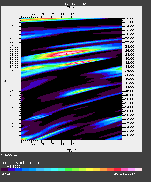
| Estimated Moho Depth: |
27.25 km |
| Estimated Crust Vp/Vs: |
1.82 |
| Assumed Crust Vp: |
6.155 km/s |
| Estimated Crust Vs: |
3.377 km/s |
| Estimated Crust Poisson's Ratio: |
0.28 |
|
| Radial Match: |
82.576355 % |
| Radial Bump: |
400 |
| Transverse Match: |
57.894836 % |
| Transverse Bump: |
400 |
| SOD ConfigId: |
13570011 |
| Insert Time: |
2019-05-02 12:39:35.484 +0000 |
| GWidth: |
2.5 |
| Max Bumps: |
400 |
| Tol: |
0.001 |
|

Signal To Noise
| Channel | StoN | STA | LTA |
| TA:N17K: :BHZ:20190208T12:06:14.950017Z | 3.9291656 | 8.2411634E-7 | 2.0974335E-7 |
| TA:N17K: :BHN:20190208T12:06:14.950017Z | 0.8944605 | 2.587091E-7 | 2.892348E-7 |
| TA:N17K: :BHE:20190208T12:06:14.950017Z | 2.0415168 | 4.3289003E-7 | 2.1204333E-7 |
| Arrivals |
| Ps | 3.7 SECOND |
| PpPs | 12 SECOND |
| PsPs/PpSs | 16 SECOND |


